You are here: Home > Network List > TA - USArray Transportable Network (new EarthScope stations) Stations List
> Station G59A Clarenceville, QC, USA > Earthquake Result Viewer
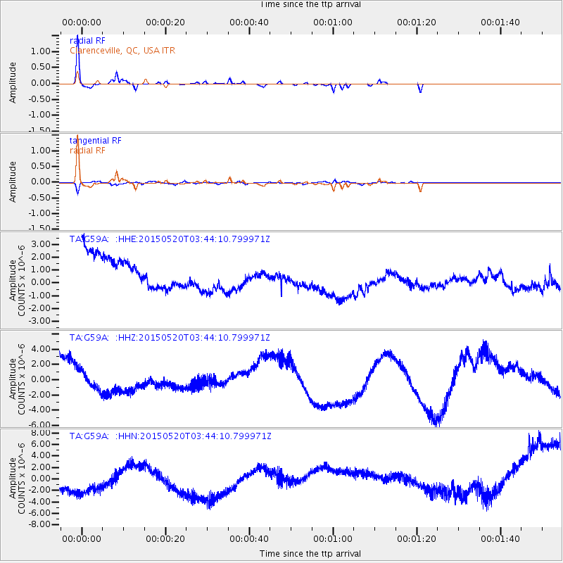
G59A Clarenceville, QC, USA - Earthquake Result Viewer
*The percent match for this event was below the threshold and hence no stack was calculated.
| Earthquake location: |
Afghanistan-Tajikistan Bord Reg. |
| Earthquake latitude/longitude: |
38.7/70.2 |
| Earthquake time(UTC): |
2015/05/20 (140) 03:31:42 GMT |
| Earthquake Depth: |
11 km |
| Earthquake Magnitude: |
5.5 MB |
| Earthquake Catalog/Contributor: |
NEIC PDE/NEIC COMCAT |
|
| Network: |
TA USArray Transportable Network (new EarthScope stations) |
| Station: |
G59A Clarenceville, QC, USA |
| Lat/Lon: |
45.08 N/73.18 W |
| Elevation: |
36 m |
|
| Distance: |
90.3 deg |
| Az: |
334.972 deg |
| Baz: |
27.871 deg |
| Ray Param: |
$rayparam |
*The percent match for this event was below the threshold and hence was not used in the summary stack. |
|
| Radial Match: |
42.93668 % |
| Radial Bump: |
161 |
| Transverse Match: |
29.533485 % |
| Transverse Bump: |
313 |
| SOD ConfigId: |
7422571 |
| Insert Time: |
2019-04-18 23:34:01.341 +0000 |
| GWidth: |
2.5 |
| Max Bumps: |
400 |
| Tol: |
0.001 |
|
Signal To Noise
| Channel | StoN | STA | LTA |
| TA:G59A: :HHZ:20150520T03:44:10.799971Z | 0.36201316 | 1.3719657E-6 | 3.7898228E-6 |
| TA:G59A: :HHN:20150520T03:44:10.799971Z | 1.293946 | 5.6715803E-6 | 4.383166E-6 |
| TA:G59A: :HHE:20150520T03:44:10.799971Z | 1.354368 | 1.4781496E-6 | 1.0913943E-6 |
| Arrivals |
| Ps | |
| PpPs | |
| PsPs/PpSs | |


