You are here: Home > Network List > TA - USArray Transportable Network (new EarthScope stations) Stations List
> Station G65A Princeton, ME, USA > Earthquake Result Viewer
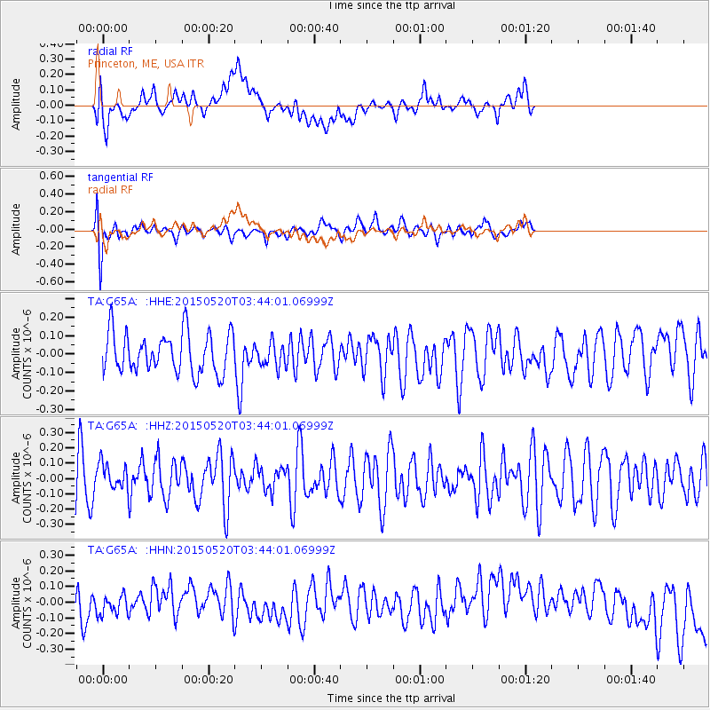
G65A Princeton, ME, USA - Earthquake Result Viewer
*The percent match for this event was below the threshold and hence no stack was calculated.
| Earthquake location: |
Afghanistan-Tajikistan Bord Reg. |
| Earthquake latitude/longitude: |
38.7/70.2 |
| Earthquake time(UTC): |
2015/05/20 (140) 03:31:42 GMT |
| Earthquake Depth: |
11 km |
| Earthquake Magnitude: |
5.5 MB |
| Earthquake Catalog/Contributor: |
NEIC PDE/NEIC COMCAT |
|
| Network: |
TA USArray Transportable Network (new EarthScope stations) |
| Station: |
G65A Princeton, ME, USA |
| Lat/Lon: |
45.20 N/67.56 W |
| Elevation: |
78 m |
|
| Distance: |
88.3 deg |
| Az: |
331.583 deg |
| Baz: |
31.799 deg |
| Ray Param: |
$rayparam |
*The percent match for this event was below the threshold and hence was not used in the summary stack. |
|
| Radial Match: |
35.287937 % |
| Radial Bump: |
400 |
| Transverse Match: |
67.927986 % |
| Transverse Bump: |
400 |
| SOD ConfigId: |
7422571 |
| Insert Time: |
2019-04-18 23:34:03.452 +0000 |
| GWidth: |
2.5 |
| Max Bumps: |
400 |
| Tol: |
0.001 |
|
Signal To Noise
| Channel | StoN | STA | LTA |
| TA:G65A: :HHZ:20150520T03:44:01.06999Z | 0.481702 | 8.7726555E-8 | 1.821179E-7 |
| TA:G65A: :HHN:20150520T03:44:01.06999Z | 0.7410334 | 6.805461E-8 | 9.183745E-8 |
| TA:G65A: :HHE:20150520T03:44:01.06999Z | 0.62025476 | 7.082875E-8 | 1.14193E-7 |
| Arrivals |
| Ps | |
| PpPs | |
| PsPs/PpSs | |


