You are here: Home > Network List > TA - USArray Transportable Network (new EarthScope stations) Stations List
> Station H17A Grant Village (NPS), Yellowstone Nt. Park, WY, USA > Earthquake Result Viewer
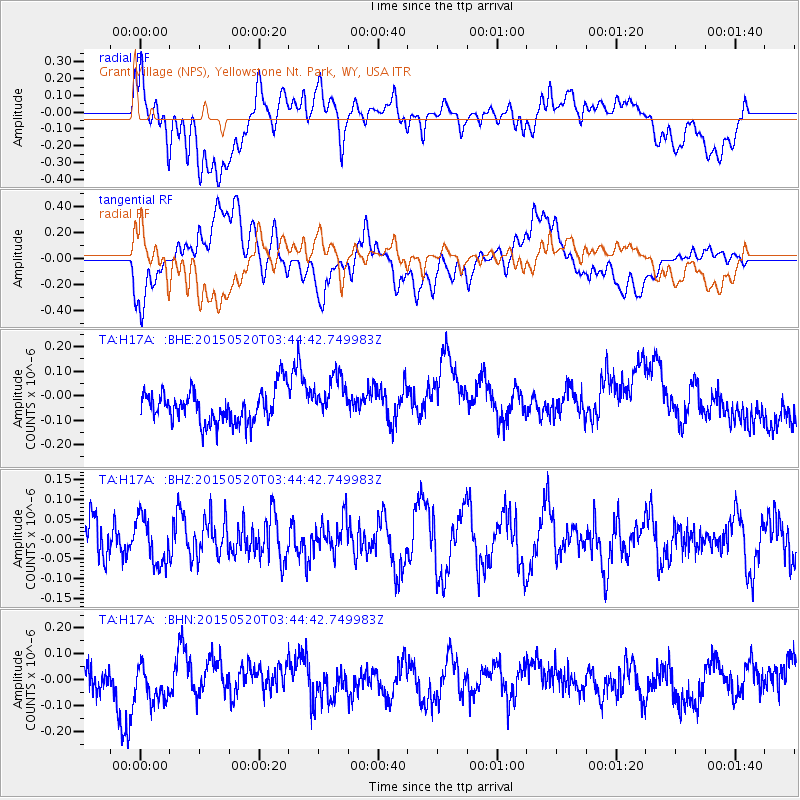
H17A Grant Village (NPS), Yellowstone Nt. Park, WY, USA - Earthquake Result Viewer
*The percent match for this event was below the threshold and hence no stack was calculated.
| Earthquake location: |
Afghanistan-Tajikistan Bord Reg. |
| Earthquake latitude/longitude: |
38.7/70.2 |
| Earthquake time(UTC): |
2015/05/20 (140) 03:31:42 GMT |
| Earthquake Depth: |
11 km |
| Earthquake Magnitude: |
5.5 MB |
| Earthquake Catalog/Contributor: |
NEIC PDE/NEIC COMCAT |
|
| Network: |
TA USArray Transportable Network (new EarthScope stations) |
| Station: |
H17A Grant Village (NPS), Yellowstone Nt. Park, WY, USA |
| Lat/Lon: |
44.40 N/110.58 W |
| Elevation: |
2400 m |
|
| Distance: |
97.3 deg |
| Az: |
0.529 deg |
| Baz: |
359.423 deg |
| Ray Param: |
$rayparam |
*The percent match for this event was below the threshold and hence was not used in the summary stack. |
|
| Radial Match: |
48.11563 % |
| Radial Bump: |
400 |
| Transverse Match: |
37.583904 % |
| Transverse Bump: |
400 |
| SOD ConfigId: |
7422571 |
| Insert Time: |
2019-04-18 23:34:03.778 +0000 |
| GWidth: |
2.5 |
| Max Bumps: |
400 |
| Tol: |
0.001 |
|
Signal To Noise
| Channel | StoN | STA | LTA |
| TA:H17A: :BHZ:20150520T03:44:42.749983Z | 0.9951321 | 5.9027567E-8 | 5.9316314E-8 |
| TA:H17A: :BHN:20150520T03:44:42.749983Z | 1.224908 | 7.404518E-8 | 6.044959E-8 |
| TA:H17A: :BHE:20150520T03:44:42.749983Z | 1.2598855 | 8.7743196E-8 | 6.964378E-8 |
| Arrivals |
| Ps | |
| PpPs | |
| PsPs/PpSs | |


