You are here: Home > Network List > IU - Global Seismograph Network (GSN - IRIS/USGS) Stations List
> Station PMG Port Moresby, New Guinea > Earthquake Result Viewer
PMG Port Moresby, New Guinea - Earthquake Result Viewer
| Earthquake location: |
Tonga Islands |
| Earthquake latitude/longitude: |
-16.8/-174.2 |
| Earthquake time(UTC): |
2004/01/25 (025) 11:43:11 GMT |
| Earthquake Depth: |
130 km |
| Earthquake Magnitude: |
6.4 MB, 6.7 MW, 6.7 MW |
| Earthquake Catalog/Contributor: |
WHDF/NEIC |
|
| Network: |
IU Global Seismograph Network (GSN - IRIS/USGS) |
| Station: |
PMG Port Moresby, New Guinea |
| Lat/Lon: |
9.41 S/147.15 E |
| Elevation: |
67 m |
|
| Distance: |
38.3 deg |
| Az: |
276.131 deg |
| Baz: |
105.195 deg |
| Ray Param: |
0.07518361 |
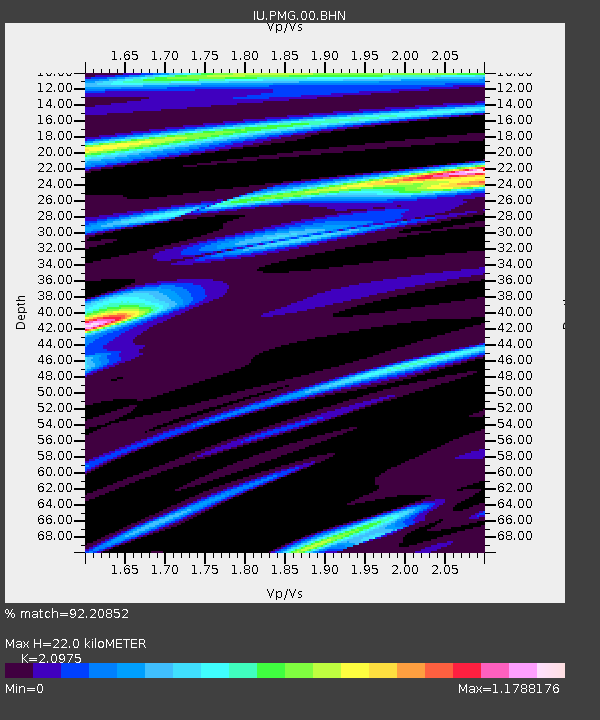
| Estimated Moho Depth: |
22.0 km |
| Estimated Crust Vp/Vs: |
2.10 |
| Assumed Crust Vp: |
6.122 km/s |
| Estimated Crust Vs: |
2.919 km/s |
| Estimated Crust Poisson's Ratio: |
0.35 |
|
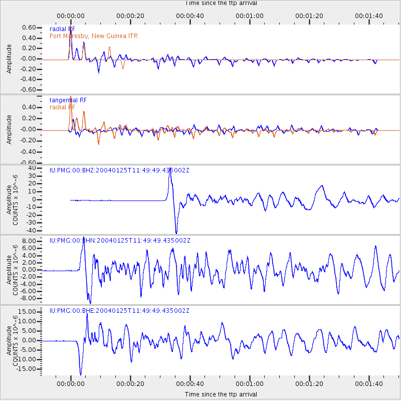
| Radial Match: |
92.20852 % |
| Radial Bump: |
336 |
| Transverse Match: |
79.07352 % |
| Transverse Bump: |
400 |
| SOD ConfigId: |
2459 |
| Insert Time: |
2010-03-02 15:08:59.088 +0000 |
| GWidth: |
2.5 |
| Max Bumps: |
400 |
| Tol: |
0.001 |
|
Signal To Noise
| Channel | StoN | STA | LTA |
| IU:PMG:00:BHN:20040125T11:49:49.435002Z | 56.53062 | 3.4371583E-6 | 6.08017E-8 |
| IU:PMG:00:BHE:20040125T11:49:49.435002Z | 97.40426 | 6.690742E-6 | 6.869044E-8 |
| IU:PMG:00:BHZ:20040125T11:49:49.435002Z | 114.99122 | 1.5781317E-5 | 1.3723931E-7 |
| Arrivals |
| Ps | 4.2 SECOND |
| PpPs | 11 SECOND |
| PsPs/PpSs | 15 SECOND |


