You are here: Home > Network List > IU - Global Seismograph Network (GSN - IRIS/USGS) Stations List
> Station PMG Port Moresby, New Guinea > Earthquake Result Viewer
PMG Port Moresby, New Guinea - Earthquake Result Viewer

| Earthquake location: |
Kuril Islands |
| Earthquake latitude/longitude: |
46.0/151.4 |
| Earthquake time(UTC): |
2009/04/18 (108) 19:17:58 GMT |
| Earthquake Depth: |
35 km |
| Earthquake Magnitude: |
6.3 MB, 6.3 MS, 6.6 MW, 6.4 MW |
| Earthquake Catalog/Contributor: |
WHDF/NEIC |
|
| Network: |
IU Global Seismograph Network (GSN - IRIS/USGS) |
| Station: |
PMG Port Moresby, New Guinea |
| Lat/Lon: |
9.41 S/147.15 E |
| Elevation: |
67 m |
|
| Distance: |
55.3 deg |
| Az: |
185.13 deg |
| Baz: |
3.621 deg |
| Ray Param: |
0.064815834 |
| Estimated Moho Depth: |
32.5 km |
| Estimated Crust Vp/Vs: |
1.81 |
| Assumed Crust Vp: |
6.122 km/s |
| Estimated Crust Vs: |
3.387 km/s |
| Estimated Crust Poisson's Ratio: |
0.28 |
|
| Radial Match: |
92.90866 % |
| Radial Bump: |
399 |
| Transverse Match: |
80.53705 % |
| Transverse Bump: |
400 |
| SOD ConfigId: |
2760 |
| Insert Time: |
2010-03-02 15:09:03.285 +0000 |
| GWidth: |
2.5 |
| Max Bumps: |
400 |
| Tol: |
0.001 |
|
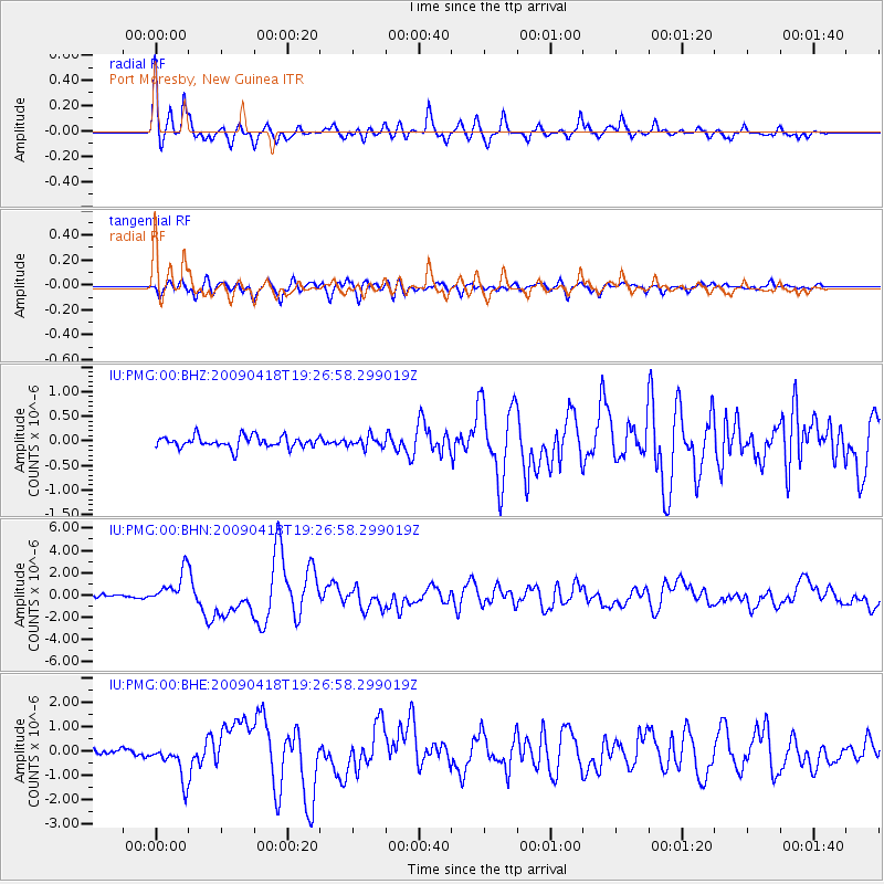
Signal To Noise
| Channel | StoN | STA | LTA |
| IU:PMG:00:BHN:20090418T19:26:58.299019Z | 9.153661 | 1.4574694E-6 | 1.5922258E-7 |
| IU:PMG:00:BHE:20090418T19:26:58.299019Z | 5.4519844 | 7.578082E-7 | 1.3899677E-7 |
| IU:PMG:00:BHZ:20090418T19:26:58.299019Z | 0.9596739 | 1.1043161E-7 | 1.1507202E-7 |
| Arrivals |
| Ps | 4.5 SECOND |
| PpPs | 14 SECOND |
| PsPs/PpSs | 19 SECOND |


