You are here: Home > Network List > TA - USArray Transportable Network (new EarthScope stations) Stations List
> Station A21K Barrow, AK, USA > Earthquake Result Viewer
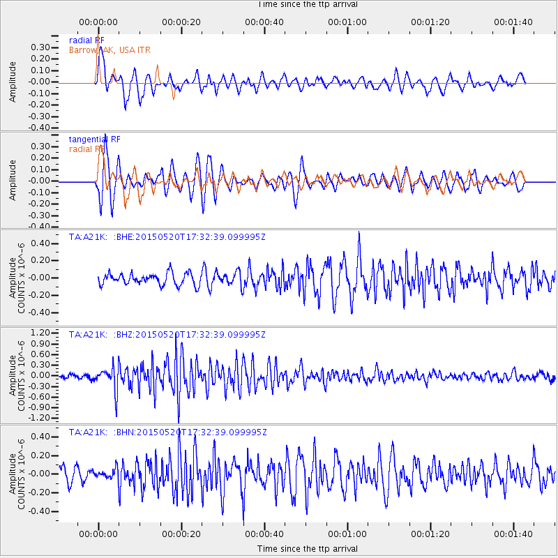
A21K Barrow, AK, USA - Earthquake Result Viewer
*The percent match for this event was below the threshold and hence no stack was calculated.
| Earthquake location: |
Northern Molucca Sea |
| Earthquake latitude/longitude: |
1.8/126.4 |
| Earthquake time(UTC): |
2015/05/20 (140) 17:20:44 GMT |
| Earthquake Depth: |
49 km |
| Earthquake Magnitude: |
5.5 MB |
| Earthquake Catalog/Contributor: |
NEIC PDE/NEIC COMCAT |
|
| Network: |
TA USArray Transportable Network (new EarthScope stations) |
| Station: |
A21K Barrow, AK, USA |
| Lat/Lon: |
71.32 N/156.62 W |
| Elevation: |
577 m |
|
| Distance: |
84.1 deg |
| Az: |
18.391 deg |
| Baz: |
258.182 deg |
| Ray Param: |
$rayparam |
*The percent match for this event was below the threshold and hence was not used in the summary stack. |
|
| Radial Match: |
63.395435 % |
| Radial Bump: |
400 |
| Transverse Match: |
76.33344 % |
| Transverse Bump: |
400 |
| SOD ConfigId: |
7422571 |
| Insert Time: |
2019-04-18 23:38:25.351 +0000 |
| GWidth: |
2.5 |
| Max Bumps: |
400 |
| Tol: |
0.001 |
|
Signal To Noise
| Channel | StoN | STA | LTA |
| TA:A21K: :BHZ:20150520T17:32:39.099995Z | 5.636506 | 3.356906E-7 | 5.9556502E-8 |
| TA:A21K: :BHN:20150520T17:32:39.099995Z | 0.5230133 | 4.95025E-8 | 9.464864E-8 |
| TA:A21K: :BHE:20150520T17:32:39.099995Z | 1.1972597 | 7.9683E-8 | 6.655448E-8 |
| Arrivals |
| Ps | |
| PpPs | |
| PsPs/PpSs | |


