You are here: Home > Network List > TA - USArray Transportable Network (new EarthScope stations) Stations List
> Station I23K Minto, Yukon-Koyukuk, AK, USA > Earthquake Result Viewer
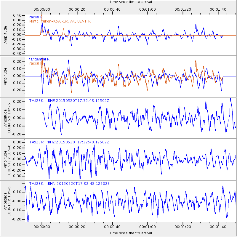
I23K Minto, Yukon-Koyukuk, AK, USA - Earthquake Result Viewer
*The percent match for this event was below the threshold and hence no stack was calculated.
| Earthquake location: |
Northern Molucca Sea |
| Earthquake latitude/longitude: |
1.8/126.4 |
| Earthquake time(UTC): |
2015/05/20 (140) 17:20:44 GMT |
| Earthquake Depth: |
49 km |
| Earthquake Magnitude: |
5.5 MB |
| Earthquake Catalog/Contributor: |
NEIC PDE/NEIC COMCAT |
|
| Network: |
TA USArray Transportable Network (new EarthScope stations) |
| Station: |
I23K Minto, Yukon-Koyukuk, AK, USA |
| Lat/Lon: |
65.15 N/149.36 W |
| Elevation: |
149 m |
|
| Distance: |
85.9 deg |
| Az: |
24.929 deg |
| Baz: |
265.493 deg |
| Ray Param: |
$rayparam |
*The percent match for this event was below the threshold and hence was not used in the summary stack. |
|
| Radial Match: |
61.005013 % |
| Radial Bump: |
393 |
| Transverse Match: |
58.259743 % |
| Transverse Bump: |
400 |
| SOD ConfigId: |
7422571 |
| Insert Time: |
2019-04-18 23:38:26.172 +0000 |
| GWidth: |
2.5 |
| Max Bumps: |
400 |
| Tol: |
0.001 |
|
Signal To Noise
| Channel | StoN | STA | LTA |
| TA:I23K: :BHZ:20150520T17:32:48.12502Z | 1.9596419 | 1.487421E-7 | 7.590269E-8 |
| TA:I23K: :BHN:20150520T17:32:48.12502Z | 0.74354947 | 6.3939936E-8 | 8.5992845E-8 |
| TA:I23K: :BHE:20150520T17:32:48.12502Z | 1.0142322 | 7.858785E-8 | 7.7485076E-8 |
| Arrivals |
| Ps | |
| PpPs | |
| PsPs/PpSs | |


