You are here: Home > Network List > CI - Caltech Regional Seismic Network Stations List
> Station DGR Domenigoni Reservoir, California, USA > Earthquake Result Viewer
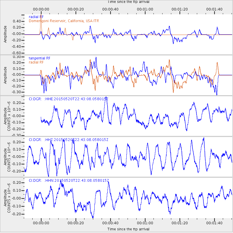
DGR Domenigoni Reservoir, California, USA - Earthquake Result Viewer
*The percent match for this event was below the threshold and hence no stack was calculated.
| Earthquake location: |
Peru-Ecuador Border Region |
| Earthquake latitude/longitude: |
-3.1/-77.7 |
| Earthquake time(UTC): |
2015/05/20 (140) 22:34:30 GMT |
| Earthquake Depth: |
20 km |
| Earthquake Magnitude: |
5.1 mb, 5.1 mb |
| Earthquake Catalog/Contributor: |
ISC/ISC |
|
| Network: |
CI Caltech Regional Seismic Network |
| Station: |
DGR Domenigoni Reservoir, California, USA |
| Lat/Lon: |
33.65 N/117.01 W |
| Elevation: |
609 m |
|
| Distance: |
52.1 deg |
| Az: |
317.93 deg |
| Baz: |
126.67 deg |
| Ray Param: |
$rayparam |
*The percent match for this event was below the threshold and hence was not used in the summary stack. |
|
| Radial Match: |
35.964138 % |
| Radial Bump: |
400 |
| Transverse Match: |
42.81581 % |
| Transverse Bump: |
400 |
| SOD ConfigId: |
7422571 |
| Insert Time: |
2019-04-18 23:41:29.094 +0000 |
| GWidth: |
2.5 |
| Max Bumps: |
400 |
| Tol: |
0.001 |
|
Signal To Noise
| Channel | StoN | STA | LTA |
| CI:DGR: :HHZ:20150520T22:43:08.058015Z | 1.2161223 | 1.2083123E-7 | 9.935779E-8 |
| CI:DGR: :HHN:20150520T22:43:08.058015Z | 0.93008643 | 6.535561E-8 | 7.0268314E-8 |
| CI:DGR: :HHE:20150520T22:43:08.058015Z | 0.7890306 | 6.57469E-8 | 8.332618E-8 |
| Arrivals |
| Ps | |
| PpPs | |
| PsPs/PpSs | |


