You are here: Home > Network List > CN - Canadian National Seismograph Network Stations List
> Station INK INUVIK, NT > Earthquake Result Viewer
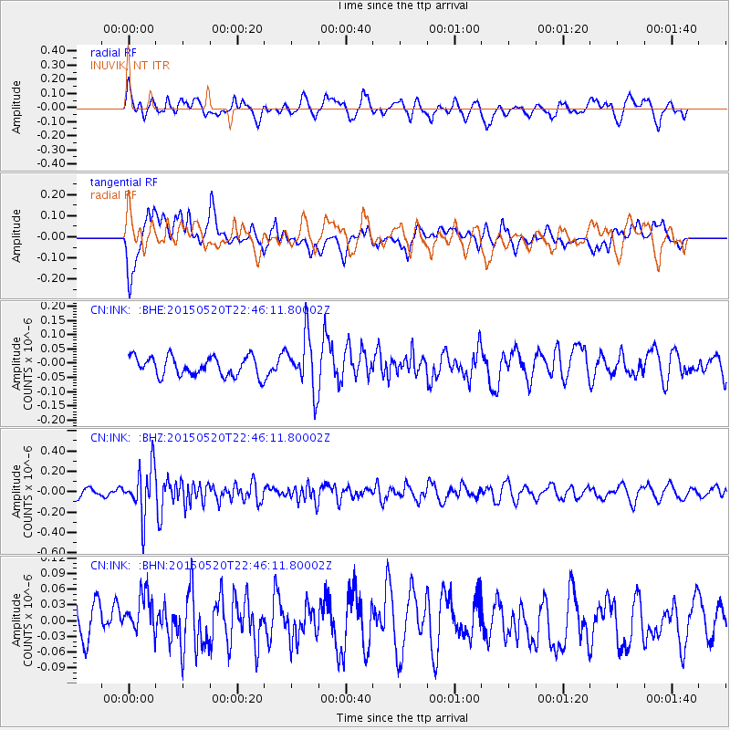
INK INUVIK, NT - Earthquake Result Viewer
*The percent match for this event was below the threshold and hence no stack was calculated.
| Earthquake location: |
Peru-Ecuador Border Region |
| Earthquake latitude/longitude: |
-3.1/-77.7 |
| Earthquake time(UTC): |
2015/05/20 (140) 22:34:30 GMT |
| Earthquake Depth: |
20 km |
| Earthquake Magnitude: |
5.1 mb, 5.1 mb |
| Earthquake Catalog/Contributor: |
ISC/ISC |
|
| Network: |
CN Canadian National Seismograph Network |
| Station: |
INK INUVIK, NT |
| Lat/Lon: |
68.31 N/133.53 W |
| Elevation: |
44 m |
|
| Distance: |
80.9 deg |
| Az: |
341.847 deg |
| Baz: |
123.199 deg |
| Ray Param: |
$rayparam |
*The percent match for this event was below the threshold and hence was not used in the summary stack. |
|
| Radial Match: |
60.36621 % |
| Radial Bump: |
400 |
| Transverse Match: |
47.91815 % |
| Transverse Bump: |
400 |
| SOD ConfigId: |
7422571 |
| Insert Time: |
2019-04-18 23:42:03.459 +0000 |
| GWidth: |
2.5 |
| Max Bumps: |
400 |
| Tol: |
0.001 |
|
Signal To Noise
| Channel | StoN | STA | LTA |
| CN:INK: :BHZ:20150520T22:46:11.80002Z | 3.2804437 | 2.4185627E-7 | 7.3726696E-8 |
| CN:INK: :BHN:20150520T22:46:11.80002Z | 0.99527895 | 4.8553044E-8 | 4.8783352E-8 |
| CN:INK: :BHE:20150520T22:46:11.80002Z | 2.9008992 | 9.720948E-8 | 3.351012E-8 |
| Arrivals |
| Ps | |
| PpPs | |
| PsPs/PpSs | |


