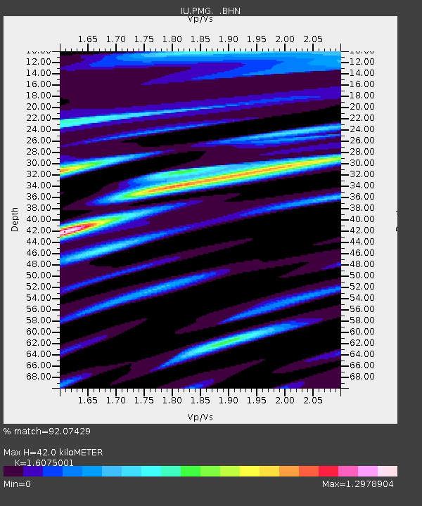
PMG Port Moresby, New Guinea - Earthquake Result Viewer

Earthquake location: Off East Coast Of Honshu, Japan
Earthquake latitude/longitude: 40.5/143.5
Earthquake time(UTC): 1994/12/28 (362) 12:19:23 GMT
Earthquake Depth: 33 km
Earthquake Magnitude: 6.4 MB, 7.5 MS, 7.2 UNKNOWN, 7.7 MW
Earthquake Catalog/Contributor: WHDF/NEIC
Network: IU Global Seismograph Network (GSN - IRIS/USGS)
Station: PMG Port Moresby, New Guinea
Lat/Lon: 9.41 S/147.15 E
Elevation: 67 m
Distance: 49.7 deg
Az: 175.261 deg
Baz: 356.336 deg
Ray Param: 0.068456404
Estimated Moho Depth: 42.0 km
Estimated Crust Vp/Vs: 1.61
Assumed Crust Vp: 6.122 km/s
Estimated Crust Vs: 3.808 km/s
Estimated Crust Poisson's Ratio: 0.18
Radial Match: 92.07429 %
Radial Bump: 400
Transverse Match: 81.46229 %
Transverse Bump: 400
SOD ConfigId: 16938
Insert Time: 2010-03-02 15:11:10.049 +0000
GWidth: 2.5
Max Bumps: 400
Tol: 0.001

Signal To Noise

ChannelStoNSTALTA
IU:PMG: :BHN:19941228T12:27:42.006006Z2.86150073.6879172E-71.2888053E-7
IU:PMG: :BHE:19941228T12:27:42.006006Z1.52279782.0403958E-71.3398993E-7
IU:PMG: :BHZ:19941228T12:27:42.006006Z1.39799184.322427E-73.091883E-7
Arrivals
Ps4.4 SECOND
PpPs17 SECOND
PsPs/PpSs21 SECOND