You are here: Home > Network List > US - United States National Seismic Network Stations List
> Station HAWA Hanford, Washington, USA > Earthquake Result Viewer
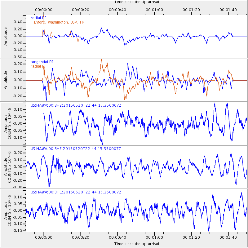
HAWA Hanford, Washington, USA - Earthquake Result Viewer
*The percent match for this event was below the threshold and hence no stack was calculated.
| Earthquake location: |
Peru-Ecuador Border Region |
| Earthquake latitude/longitude: |
-3.1/-77.7 |
| Earthquake time(UTC): |
2015/05/20 (140) 22:34:30 GMT |
| Earthquake Depth: |
20 km |
| Earthquake Magnitude: |
5.1 mb, 5.1 mb |
| Earthquake Catalog/Contributor: |
ISC/ISC |
|
| Network: |
US United States National Seismic Network |
| Station: |
HAWA Hanford, Washington, USA |
| Lat/Lon: |
46.39 N/119.53 W |
| Elevation: |
364 m |
|
| Distance: |
61.6 deg |
| Az: |
328.333 deg |
| Baz: |
130.766 deg |
| Ray Param: |
$rayparam |
*The percent match for this event was below the threshold and hence was not used in the summary stack. |
|
| Radial Match: |
49.979156 % |
| Radial Bump: |
400 |
| Transverse Match: |
66.80409 % |
| Transverse Bump: |
400 |
| SOD ConfigId: |
7422571 |
| Insert Time: |
2019-04-18 23:46:53.371 +0000 |
| GWidth: |
2.5 |
| Max Bumps: |
400 |
| Tol: |
0.001 |
|
Signal To Noise
| Channel | StoN | STA | LTA |
| US:HAWA:00:BHZ:20150520T22:44:15.350007Z | 1.9711269 | 1.458064E-7 | 7.397109E-8 |
| US:HAWA:00:BH1:20150520T22:44:15.350007Z | 0.67029274 | 2.5852913E-8 | 3.8569585E-8 |
| US:HAWA:00:BH2:20150520T22:44:15.350007Z | 1.4248993 | 7.47621E-8 | 5.2468337E-8 |
| Arrivals |
| Ps | |
| PpPs | |
| PsPs/PpSs | |


