You are here: Home > Network List > UW - Pacific Northwest Regional Seismic Network Stations List
> Station HOOD Mt Hood Meadows, OR CREST BB SMO > Earthquake Result Viewer
HOOD Mt Hood Meadows, OR CREST BB SMO - Earthquake Result Viewer
*The percent match for this event was below the threshold and hence no stack was calculated.
| Earthquake location: |
Peru-Ecuador Border Region |
| Earthquake latitude/longitude: |
-3.1/-77.7 |
| Earthquake time(UTC): |
2015/05/20 (140) 22:34:30 GMT |
| Earthquake Depth: |
20 km |
| Earthquake Magnitude: |
5.1 mb, 5.1 mb |
| Earthquake Catalog/Contributor: |
ISC/ISC |
|
| Network: |
UW Pacific Northwest Regional Seismic Network |
| Station: |
HOOD Mt Hood Meadows, OR CREST BB SMO |
| Lat/Lon: |
45.32 N/121.65 W |
| Elevation: |
1520 m |
|
| Distance: |
62.0 deg |
| Az: |
326.326 deg |
| Baz: |
128.301 deg |
| Ray Param: |
$rayparam |
*The percent match for this event was below the threshold and hence was not used in the summary stack. |
|
| Radial Match: |
32.82171 % |
| Radial Bump: |
400 |
| Transverse Match: |
50.799683 % |
| Transverse Bump: |
400 |
| SOD ConfigId: |
7422571 |
| Insert Time: |
2019-04-18 23:47:08.412 +0000 |
| GWidth: |
2.5 |
| Max Bumps: |
400 |
| Tol: |
0.001 |
|
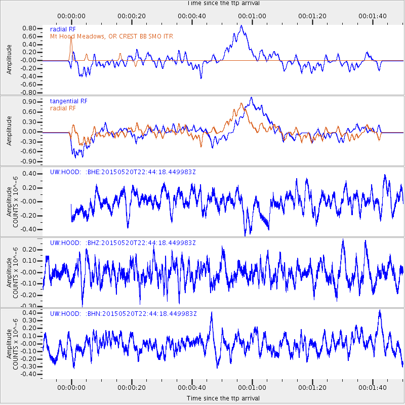
Signal To Noise
| Channel | StoN | STA | LTA |
| UW:HOOD: :BHZ:20150520T22:44:18.449983Z | 1.2406067 | 1.07449914E-7 | 8.661078E-8 |
| UW:HOOD: :BHN:20150520T22:44:18.449983Z | 0.8926187 | 1.9417719E-7 | 2.1753654E-7 |
| UW:HOOD: :BHE:20150520T22:44:18.449983Z | 1.2119755 | 1.6078839E-7 | 1.3266637E-7 |
| Arrivals |
| Ps | |
| PpPs | |
| PsPs/PpSs | |


