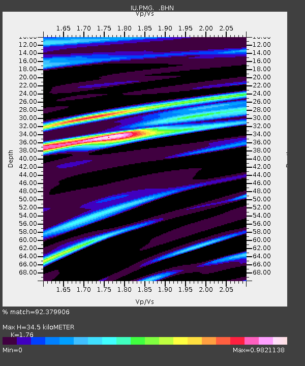
PMG Port Moresby, New Guinea - Earthquake Result Viewer

Earthquake location: Northern Sumatra, Indonesia
Earthquake latitude/longitude: 3.0/96.3
Earthquake time(UTC): 1994/10/31 (304) 11:48:15 GMT
Earthquake Depth: 46 km
Earthquake Magnitude: 5.6 MB, 6.1 MS, 6.3 UNKNOWN, 6.2 MW
Earthquake Catalog/Contributor: WHDF/NEIC
Network: IU Global Seismograph Network (GSN - IRIS/USGS)
Station: PMG Port Moresby, New Guinea
Lat/Lon: 9.41 S/147.15 E
Elevation: 67 m
Distance: 52.2 deg
Az: 104.283 deg
Baz: 281.254 deg
Ray Param: 0.066812485
Estimated Moho Depth: 34.5 km
Estimated Crust Vp/Vs: 1.76
Assumed Crust Vp: 6.122 km/s
Estimated Crust Vs: 3.478 km/s
Estimated Crust Poisson's Ratio: 0.26
Radial Match: 92.379906 %
Radial Bump: 400
Transverse Match: 69.81401 %
Transverse Bump: 400
SOD ConfigId: 17000
Insert Time: 2010-03-02 15:11:32.315 +0000
GWidth: 2.5
Max Bumps: 400
Tol: 0.001

Signal To Noise

ChannelStoNSTALTA
IU:PMG: :BHN:19941031T11:56:51.452002Z3.3898692.2852832E-76.741509E-8
IU:PMG: :BHE:19941031T11:56:51.452002Z8.8830426.2449703E-77.030216E-8
IU:PMG: :BHZ:19941031T11:56:51.452002Z13.5103481.2577962E-69.309873E-8
Arrivals
Ps4.5 SECOND
PpPs15 SECOND
PsPs/PpSs19 SECOND