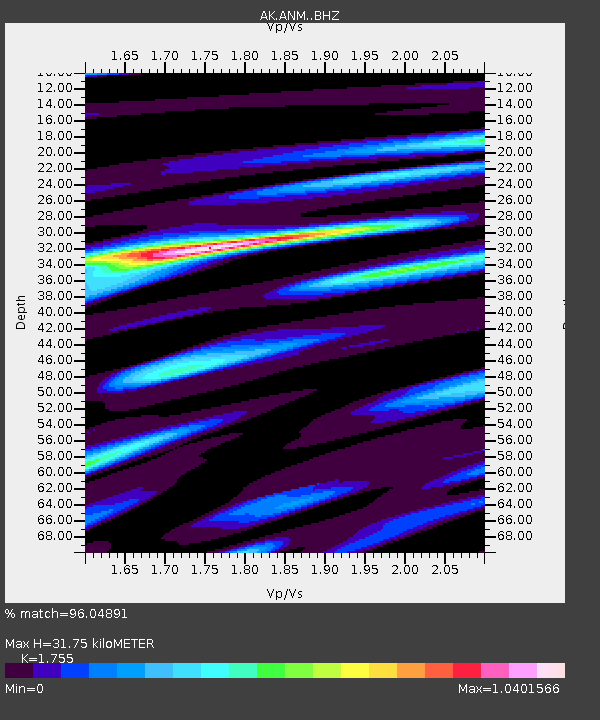
ANM Anvil Mountian - Earthquake Result Viewer

Earthquake location: Santa Cruz Islands Region
Earthquake latitude/longitude: -10.9/164.2
Earthquake time(UTC): 2015/05/20 (140) 22:48:53 GMT
Earthquake Depth: 12 km
Earthquake Magnitude: 6.8 MWW, 6.7 MWB, 6.8 MWC, 6.9 MI
Earthquake Catalog/Contributor: NEIC PDE/NEIC COMCAT
Network: AK Alaska Regional Network
Station: ANM Anvil Mountian
Lat/Lon: 64.56 N/165.37 W
Elevation: 330 m
Distance: 78.7 deg
Az: 12.908 deg
Baz: 210.531 deg
Ray Param: 0.049476955
Estimated Moho Depth: 31.75 km
Estimated Crust Vp/Vs: 1.75
Assumed Crust Vp: 6.276 km/s
Estimated Crust Vs: 3.576 km/s
Estimated Crust Poisson's Ratio: 0.26
Radial Match: 96.04891 %
Radial Bump: 344
Transverse Match: 55.00967 %
Transverse Bump: 400
SOD ConfigId: 7422571
Insert Time: 2019-04-18 23:48:38.950 +0000
GWidth: 2.5
Max Bumps: 400
Tol: 0.001

Signal To Noise

ChannelStoNSTALTA
AK:ANM: :BHZ:20150520T23:00:24.347974Z5.4234986.8215377E-71.2577745E-7
AK:ANM: :BHN:20150520T23:00:24.347974Z0.99408552.9393692E-72.9568574E-7
AK:ANM: :BHE:20150520T23:00:24.347974Z1.120515.0314145E-74.4902896E-7
Arrivals
Ps3.9 SECOND
PpPs14 SECOND
PsPs/PpSs17 SECOND