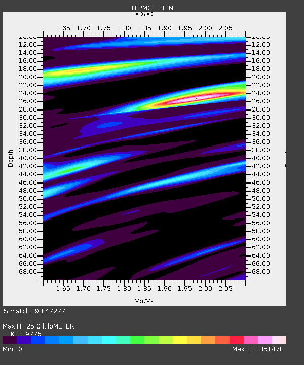
PMG Port Moresby, New Guinea - Earthquake Result Viewer

Earthquake location: Kermadec Islands, New Zealand
Earthquake latitude/longitude: -29.2/-177.6
Earthquake time(UTC): 1995/07/03 (184) 19:50:50 GMT
Earthquake Depth: 33 km
Earthquake Magnitude: 6.5 MB, 7.2 MS, 7.2 UNKNOWN, 7.2 MW
Earthquake Catalog/Contributor: WHDF/NEIC
Network: IU Global Seismograph Network (GSN - IRIS/USGS)
Station: PMG Port Moresby, New Guinea
Lat/Lon: 9.41 S/147.15 E
Elevation: 67 m
Distance: 38.4 deg
Az: 293.638 deg
Baz: 125.733 deg
Ray Param: 0.07550955
Estimated Moho Depth: 25.0 km
Estimated Crust Vp/Vs: 1.98
Assumed Crust Vp: 6.122 km/s
Estimated Crust Vs: 3.096 km/s
Estimated Crust Poisson's Ratio: 0.33
Radial Match: 93.47277 %
Radial Bump: 400
Transverse Match: 80.272766 %
Transverse Bump: 400
SOD ConfigId: 6273
Insert Time: 2010-03-02 15:11:48.935 +0000
GWidth: 2.5
Max Bumps: 400
Tol: 0.001

Signal To Noise

ChannelStoNSTALTA
IU:PMG: :BHN:19950703T19:57:38.102991Z1.62947424.9427746E-73.0333555E-7
IU:PMG: :BHE:19950703T19:57:38.102991Z2.75962359.060272E-73.283155E-7
IU:PMG: :BHZ:19950703T19:57:38.102991Z8.4285072.1087917E-62.5019753E-7
Arrivals
Ps4.2 SECOND
PpPs11 SECOND
PsPs/PpSs16 SECOND