You are here: Home > Network List > IU - Global Seismograph Network (GSN - IRIS/USGS) Stations List
> Station PMG Port Moresby, New Guinea > Earthquake Result Viewer
PMG Port Moresby, New Guinea - Earthquake Result Viewer
| Earthquake location: |
Samar, Philippines |
| Earthquake latitude/longitude: |
12.1/125.9 |
| Earthquake time(UTC): |
1995/04/21 (111) 05:17:00 GMT |
| Earthquake Depth: |
23 km |
| Earthquake Magnitude: |
5.6 MB, 6.9 MS, 6.7 UNKNOWN, 6.7 MW |
| Earthquake Catalog/Contributor: |
WHDF/NEIC |
|
| Network: |
IU Global Seismograph Network (GSN - IRIS/USGS) |
| Station: |
PMG Port Moresby, New Guinea |
| Lat/Lon: |
9.41 S/147.15 E |
| Elevation: |
67 m |
|
| Distance: |
30.0 deg |
| Az: |
134.528 deg |
| Baz: |
315.045 deg |
| Ray Param: |
0.079419225 |
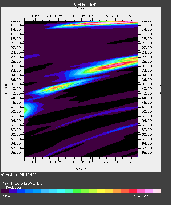
| Estimated Moho Depth: |
10.5 km |
| Estimated Crust Vp/Vs: |
2.06 |
| Assumed Crust Vp: |
6.122 km/s |
| Estimated Crust Vs: |
2.979 km/s |
| Estimated Crust Poisson's Ratio: |
0.34 |
|
| Radial Match: |
95.11449 % |
| Radial Bump: |
295 |
| Transverse Match: |
76.940056 % |
| Transverse Bump: |
400 |
| SOD ConfigId: |
6273 |
| Insert Time: |
2010-03-02 15:12:25.536 +0000 |
| GWidth: |
2.5 |
| Max Bumps: |
400 |
| Tol: |
0.001 |
|
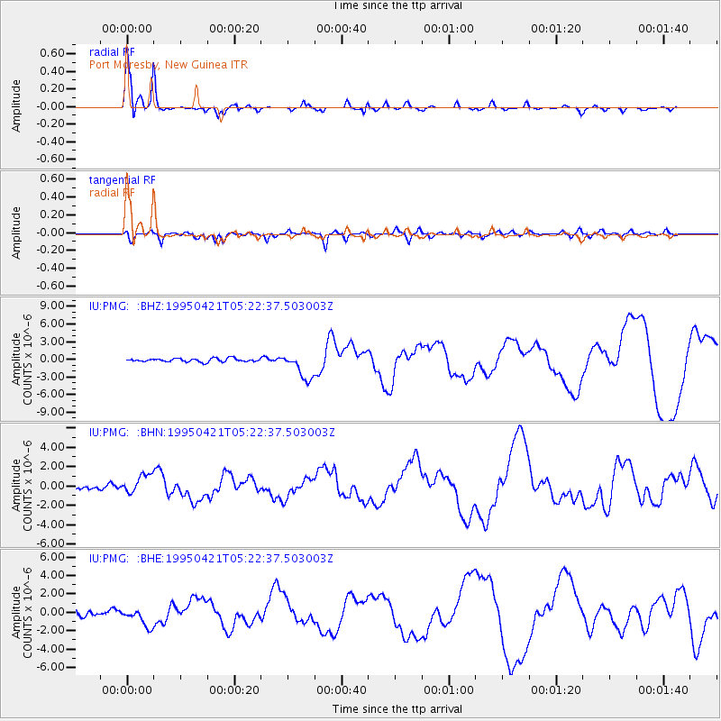
Signal To Noise
| Channel | StoN | STA | LTA |
| IU:PMG: :BHN:19950421T05:22:37.503003Z | 4.4516625 | 1.0215703E-6 | 2.2948063E-7 |
| IU:PMG: :BHE:19950421T05:22:37.503003Z | 3.2569315 | 1.0545707E-6 | 3.237927E-7 |
| IU:PMG: :BHZ:19950421T05:22:37.503003Z | 7.8820353 | 2.2988063E-6 | 2.9165136E-7 |
| Arrivals |
| Ps | 1.9 SECOND |
| PpPs | 4.9 SECOND |
| PsPs/PpSs | 6.8 SECOND |


