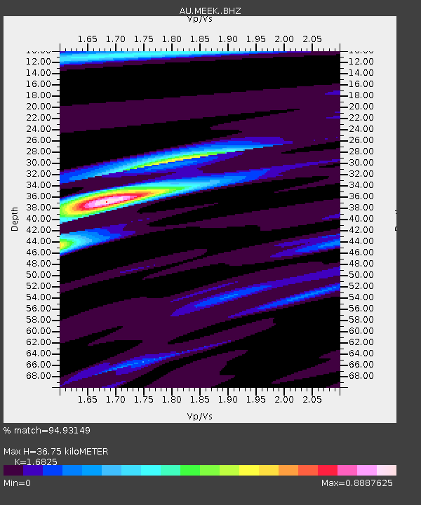
MEEK Meekatharra, Western Australia - Earthquake Result Viewer

Earthquake location: Santa Cruz Islands Region
Earthquake latitude/longitude: -10.9/164.2
Earthquake time(UTC): 2015/05/20 (140) 22:48:53 GMT
Earthquake Depth: 12 km
Earthquake Magnitude: 6.8 MWW, 6.7 MWB, 6.8 MWC, 6.9 MI
Earthquake Catalog/Contributor: NEIC PDE/NEIC COMCAT
Network: AU Australian Seismological Centre
Station: MEEK Meekatharra, Western Australia
Lat/Lon: 26.64 S/118.61 E
Elevation: 530 m
Distance: 45.6 deg
Az: 243.368 deg
Baz: 78.802 deg
Ray Param: 0.071153484
Estimated Moho Depth: 36.75 km
Estimated Crust Vp/Vs: 1.68
Assumed Crust Vp: 6.459 km/s
Estimated Crust Vs: 3.839 km/s
Estimated Crust Poisson's Ratio: 0.23
Radial Match: 94.93149 %
Radial Bump: 196
Transverse Match: 57.881905 %
Transverse Bump: 400
SOD ConfigId: 7422571
Insert Time: 2019-04-18 23:49:54.126 +0000
GWidth: 2.5
Max Bumps: 400
Tol: 0.001

Signal To Noise

ChannelStoNSTALTA
AU:MEEK: :BHZ:20150520T22:56:42.869Z5.0118511.5498633E-63.0923974E-7
AU:MEEK: :BHN:20150520T22:56:42.869Z1.7942863.81589E-72.12669E-7
AU:MEEK: :BHE:20150520T22:56:42.869Z5.31689641.1013793E-62.0714702E-7
Arrivals
Ps4.2 SECOND
PpPs14 SECOND
PsPs/PpSs18 SECOND