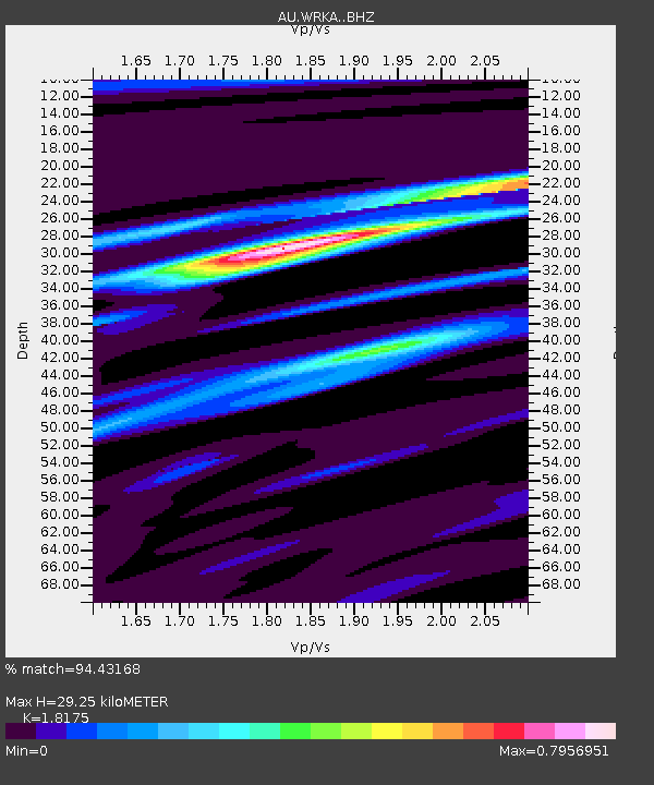
WRKA Warrakurna, Western Australia - Earthquake Result Viewer

Earthquake location: Santa Cruz Islands Region
Earthquake latitude/longitude: -10.9/164.2
Earthquake time(UTC): 2015/05/20 (140) 22:48:53 GMT
Earthquake Depth: 12 km
Earthquake Magnitude: 6.8 MWW, 6.7 MWB, 6.8 MWC, 6.9 MI
Earthquake Catalog/Contributor: NEIC PDE/NEIC COMCAT
Network: AU Australian Seismological Centre
Station: WRKA Warrakurna, Western Australia
Lat/Lon: 25.04 S/128.30 E
Elevation: 622 m
Distance: 36.8 deg
Az: 242.603 deg
Baz: 74.02 deg
Ray Param: 0.07649682
Estimated Moho Depth: 29.25 km
Estimated Crust Vp/Vs: 1.82
Assumed Crust Vp: 6.51 km/s
Estimated Crust Vs: 3.582 km/s
Estimated Crust Poisson's Ratio: 0.28
Radial Match: 94.43168 %
Radial Bump: 337
Transverse Match: 75.69675 %
Transverse Bump: 400
SOD ConfigId: 7422571
Insert Time: 2019-04-18 23:50:00.783 +0000
GWidth: 2.5
Max Bumps: 400
Tol: 0.001

Signal To Noise

ChannelStoNSTALTA
AU:WRKA: :BHZ:20150520T22:55:30.219006Z5.8957941.8809101E-63.1902576E-7
AU:WRKA: :BHN:20150520T22:55:30.219006Z1.6214394.3448662E-72.679636E-7
AU:WRKA: :BHE:20150520T22:55:30.219006Z4.50629851.2547883E-62.7845212E-7
Arrivals
Ps4.0 SECOND
PpPs12 SECOND
PsPs/PpSs16 SECOND