You are here: Home > Network List > AZ - ANZA Regional Network Stations List
> Station MONP2 Monument Peak TA Vault, Anza, CA, USA > Earthquake Result Viewer
MONP2 Monument Peak TA Vault, Anza, CA, USA - Earthquake Result Viewer

| Earthquake location: |
Santa Cruz Islands Region |
| Earthquake latitude/longitude: |
-10.9/164.2 |
| Earthquake time(UTC): |
2015/05/20 (140) 22:48:53 GMT |
| Earthquake Depth: |
12 km |
| Earthquake Magnitude: |
6.8 MWW, 6.7 MWB, 6.8 MWC, 6.9 MI |
| Earthquake Catalog/Contributor: |
NEIC PDE/NEIC COMCAT |
|
| Network: |
AZ ANZA Regional Network |
| Station: |
MONP2 Monument Peak TA Vault, Anza, CA, USA |
| Lat/Lon: |
32.89 N/116.42 W |
| Elevation: |
1000 m |
|
| Distance: |
87.1 deg |
| Az: |
55.904 deg |
| Baz: |
255.185 deg |
| Ray Param: |
0.043552287 |
| Estimated Moho Depth: |
25.75 km |
| Estimated Crust Vp/Vs: |
2.10 |
| Assumed Crust Vp: |
6.264 km/s |
| Estimated Crust Vs: |
2.986 km/s |
| Estimated Crust Poisson's Ratio: |
0.35 |
|
| Radial Match: |
89.797005 % |
| Radial Bump: |
395 |
| Transverse Match: |
75.97781 % |
| Transverse Bump: |
400 |
| SOD ConfigId: |
7422571 |
| Insert Time: |
2019-04-18 23:50:19.452 +0000 |
| GWidth: |
2.5 |
| Max Bumps: |
400 |
| Tol: |
0.001 |
|
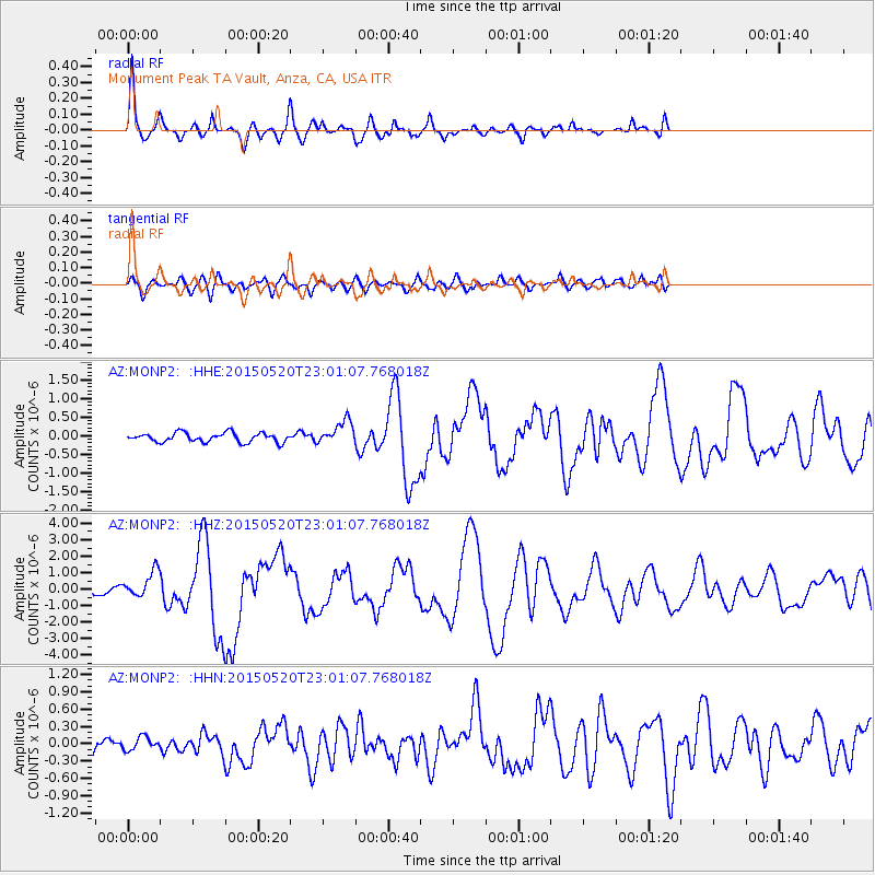
Signal To Noise
| Channel | StoN | STA | LTA |
| AZ:MONP2: :HHZ:20150520T23:01:07.768018Z | 4.8364854 | 8.1629815E-7 | 1.6877921E-7 |
| AZ:MONP2: :HHN:20150520T23:01:07.768018Z | 1.017573 | 1.0985457E-7 | 1.07957426E-7 |
| AZ:MONP2: :HHE:20150520T23:01:07.768018Z | 2.4703963 | 3.1210251E-7 | 1.2633703E-7 |
| Arrivals |
| Ps | 4.6 SECOND |
| PpPs | 13 SECOND |
| PsPs/PpSs | 17 SECOND |


