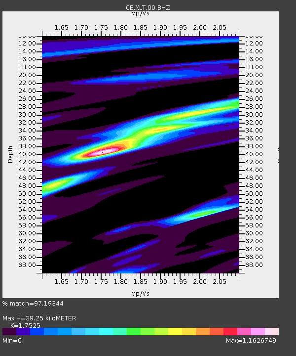
XLT Xilinhaote,Neimeng Province - Earthquake Result Viewer

Earthquake location: Santa Cruz Islands Region
Earthquake latitude/longitude: -10.9/164.2
Earthquake time(UTC): 2015/05/20 (140) 22:48:53 GMT
Earthquake Depth: 12 km
Earthquake Magnitude: 6.8 MWW, 6.7 MWB, 6.8 MWC, 6.9 MI
Earthquake Catalog/Contributor: NEIC PDE/NEIC COMCAT
Network: CB China National Seismic Network
Station: XLT Xilinhaote,Neimeng Province
Lat/Lon: 43.90 N/116.08 E
Elevation: 1030 m
Distance: 69.8 deg
Az: 325.042 deg
Baz: 128.871 deg
Ray Param: 0.055377364
Estimated Moho Depth: 39.25 km
Estimated Crust Vp/Vs: 1.75
Assumed Crust Vp: 6.459 km/s
Estimated Crust Vs: 3.686 km/s
Estimated Crust Poisson's Ratio: 0.26
Radial Match: 97.19344 %
Radial Bump: 204
Transverse Match: 82.581894 %
Transverse Bump: 400
SOD ConfigId: 7422571
Insert Time: 2019-04-18 23:50:42.360 +0000
GWidth: 2.5
Max Bumps: 400
Tol: 0.001

Signal To Noise

ChannelStoNSTALTA
CB:XLT:00:BHZ:20150520T22:59:33.02998Z3.33286953.0126688E-79.039264E-8
CB:XLT:00:BHN:20150520T22:59:33.02998Z1.92112471.4737229E-77.6711466E-8
CB:XLT:00:BHE:20150520T22:59:33.02998Z1.62540981.291108E-77.9432766E-8
Arrivals
Ps4.8 SECOND
PpPs16 SECOND
PsPs/PpSs21 SECOND