PMG Port Moresby, New Guinea - Earthquake Result Viewer
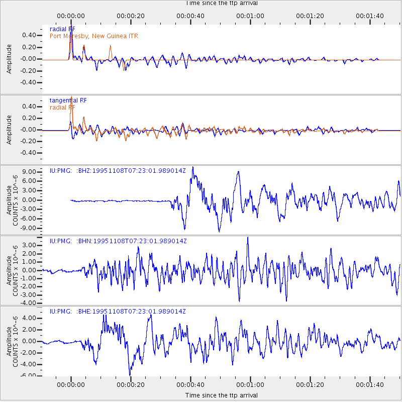
Earthquake location: Off W Coast Of Northern Sumatra
Earthquake latitude/longitude: 1.9/95.1
Earthquake time(UTC): 1995/11/08 (312) 07:14:18 GMT
Earthquake Depth: 33 km
Earthquake Magnitude: 6.1 MB, 6.9 MS, 6.7 UNKNOWN, 6.9 MW
Earthquake Catalog/Contributor: WHDF/NEIC
Network: IU Global Seismograph Network (GSN - IRIS/USGS)
Station: PMG Port Moresby, New Guinea
Lat/Lon: 9.41 S/147.15 E
Elevation: 67 m
Distance: 53.1 deg
Az: 103.145 deg
Baz: 279.462 deg
Ray Param: 0.06627753
Estimated Moho Depth: 33.5 km
Estimated Crust Vp/Vs: 1.75
Assumed Crust Vp: 6.122 km/s
Estimated Crust Vs: 3.498 km/s
Estimated Crust Poisson's Ratio: 0.26
Radial Match: 92.73275 %
Radial Bump: 400
Transverse Match: 72.68367 %
Transverse Bump: 400
SOD ConfigId: 6273
Insert Time: 2010-03-02 15:12:56.116 +0000
GWidth: 2.5
Max Bumps: 400
Tol: 0.001

Signal To Noise

ChannelStoNSTALTA
IU:PMG: :BHN:19951108T07:23:01.989014Z1.89961522.0157549E-71.0611386E-7
IU:PMG: :BHE:19951108T07:23:01.989014Z3.05015353.8696209E-71.2686644E-7
IU:PMG: :BHZ:19951108T07:23:01.989014Z7.70744858.076568E-71.0478913E-7
Arrivals
Ps4.3 SECOND
PpPs14 SECOND
PsPs/PpSs19 SECOND