You are here: Home > Network List > CI - Caltech Regional Seismic Network Stations List
> Station DAN Danby, California, USA > Earthquake Result Viewer
DAN Danby, California, USA - Earthquake Result Viewer
| Earthquake location: |
Santa Cruz Islands Region |
| Earthquake latitude/longitude: |
-10.9/164.2 |
| Earthquake time(UTC): |
2015/05/20 (140) 22:48:53 GMT |
| Earthquake Depth: |
12 km |
| Earthquake Magnitude: |
6.8 MWW, 6.7 MWB, 6.8 MWC, 6.9 MI |
| Earthquake Catalog/Contributor: |
NEIC PDE/NEIC COMCAT |
|
| Network: |
CI Caltech Regional Seismic Network |
| Station: |
DAN Danby, California, USA |
| Lat/Lon: |
34.64 N/115.38 W |
| Elevation: |
398 m |
|
| Distance: |
88.4 deg |
| Az: |
54.436 deg |
| Baz: |
255.703 deg |
| Ray Param: |
0.04261568 |
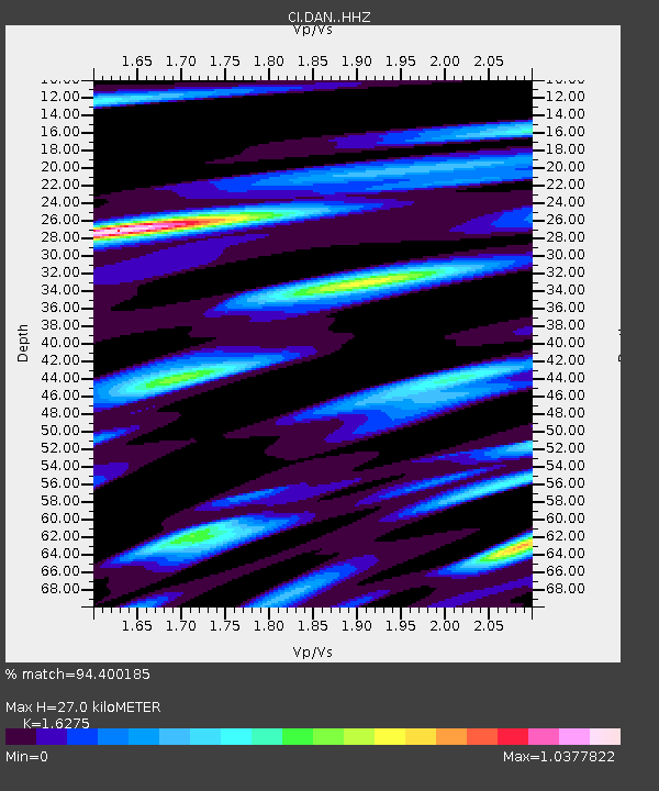
| Estimated Moho Depth: |
27.0 km |
| Estimated Crust Vp/Vs: |
1.63 |
| Assumed Crust Vp: |
6.276 km/s |
| Estimated Crust Vs: |
3.856 km/s |
| Estimated Crust Poisson's Ratio: |
0.20 |
|
| Radial Match: |
94.400185 % |
| Radial Bump: |
400 |
| Transverse Match: |
74.17562 % |
| Transverse Bump: |
400 |
| SOD ConfigId: |
7422571 |
| Insert Time: |
2019-04-18 23:51:05.794 +0000 |
| GWidth: |
2.5 |
| Max Bumps: |
400 |
| Tol: |
0.001 |
|

Signal To Noise
| Channel | StoN | STA | LTA |
| CI:DAN: :HHZ:20150520T23:01:13.878003Z | 7.8809814 | 6.915671E-7 | 8.7751395E-8 |
| CI:DAN: :HHN:20150520T23:01:13.878003Z | 2.1426263 | 1.9026828E-7 | 8.8801436E-8 |
| CI:DAN: :HHE:20150520T23:01:13.878003Z | 4.232312 | 3.7162118E-7 | 8.780572E-8 |
| Arrivals |
| Ps | 2.8 SECOND |
| PpPs | 11 SECOND |
| PsPs/PpSs | 14 SECOND |


