You are here: Home > Network List > CI - Caltech Regional Seismic Network Stations List
> Station LRL Laurel Mtn Radio Fac, Ridgecrest, CA, USA > Earthquake Result Viewer
LRL Laurel Mtn Radio Fac, Ridgecrest, CA, USA - Earthquake Result Viewer
| Earthquake location: |
Santa Cruz Islands Region |
| Earthquake latitude/longitude: |
-10.9/164.2 |
| Earthquake time(UTC): |
2015/05/20 (140) 22:48:53 GMT |
| Earthquake Depth: |
12 km |
| Earthquake Magnitude: |
6.8 MWW, 6.7 MWB, 6.8 MWC, 6.9 MI |
| Earthquake Catalog/Contributor: |
NEIC PDE/NEIC COMCAT |
|
| Network: |
CI Caltech Regional Seismic Network |
| Station: |
LRL Laurel Mtn Radio Fac, Ridgecrest, CA, USA |
| Lat/Lon: |
35.48 N/117.68 W |
| Elevation: |
1340 m |
|
| Distance: |
86.8 deg |
| Az: |
53.135 deg |
| Baz: |
254.332 deg |
| Ray Param: |
0.043793578 |
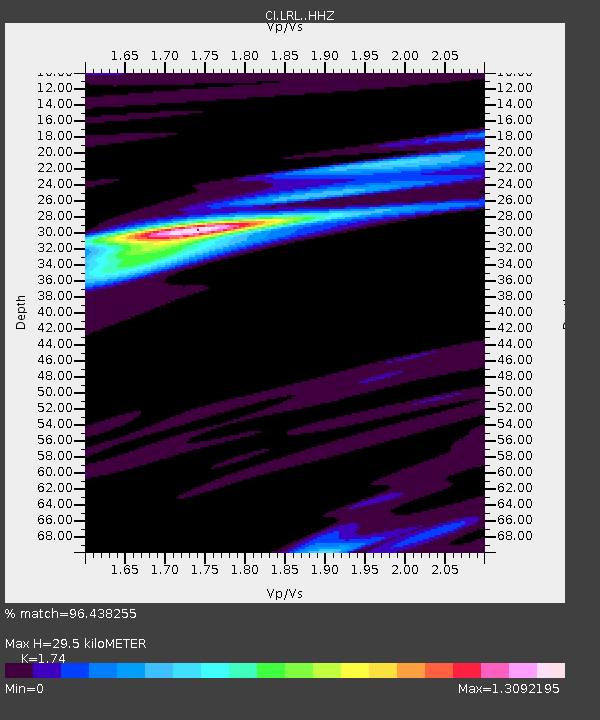
| Estimated Moho Depth: |
29.5 km |
| Estimated Crust Vp/Vs: |
1.74 |
| Assumed Crust Vp: |
6.276 km/s |
| Estimated Crust Vs: |
3.607 km/s |
| Estimated Crust Poisson's Ratio: |
0.25 |
|
| Radial Match: |
96.438255 % |
| Radial Bump: |
367 |
| Transverse Match: |
82.54565 % |
| Transverse Bump: |
400 |
| SOD ConfigId: |
7422571 |
| Insert Time: |
2019-04-18 23:51:17.777 +0000 |
| GWidth: |
2.5 |
| Max Bumps: |
400 |
| Tol: |
0.001 |
|
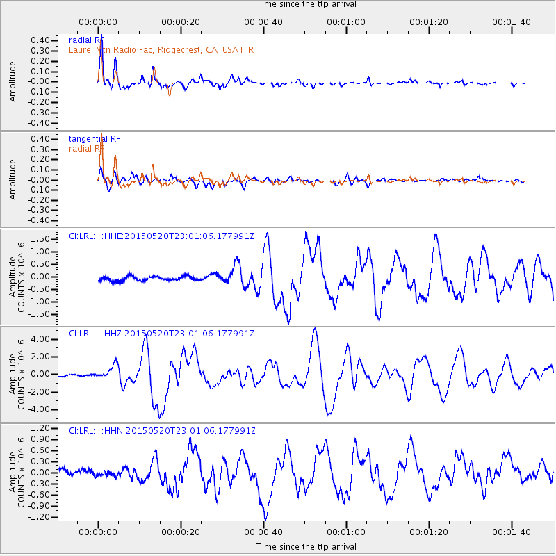
Signal To Noise
| Channel | StoN | STA | LTA |
| CI:LRL: :HHZ:20150520T23:01:06.177991Z | 11.266799 | 8.283154E-7 | 7.351826E-8 |
| CI:LRL: :HHN:20150520T23:01:06.177991Z | 0.6765006 | 6.894259E-8 | 1.01910615E-7 |
| CI:LRL: :HHE:20150520T23:01:06.177991Z | 4.484493 | 4.0181436E-7 | 8.9600846E-8 |
| Arrivals |
| Ps | 3.6 SECOND |
| PpPs | 13 SECOND |
| PsPs/PpSs | 16 SECOND |


