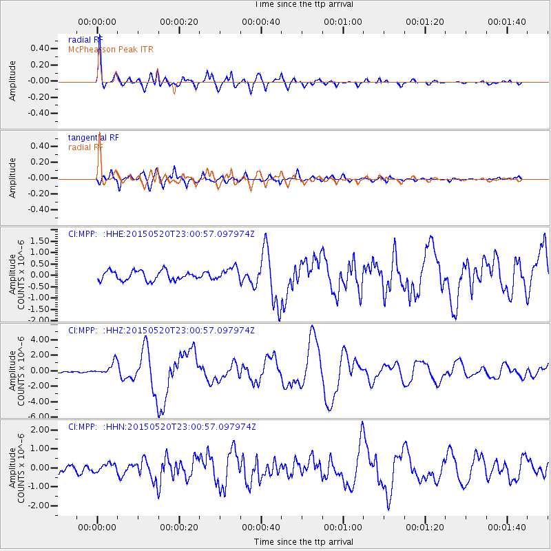
MPP McPhearson Peak - Earthquake Result Viewer
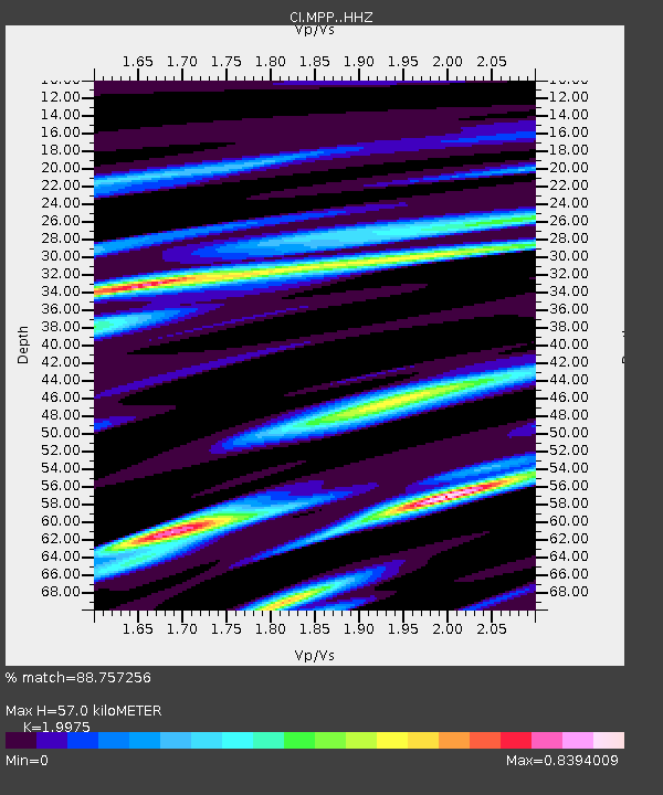
Earthquake location: Santa Cruz Islands Region
Earthquake latitude/longitude: -10.9/164.2
Earthquake time(UTC): 2015/05/20 (140) 22:48:53 GMT
Earthquake Depth: 12 km
Earthquake Magnitude: 6.8 MWW, 6.7 MWB, 6.8 MWC, 6.9 MI
Earthquake Catalog/Contributor: NEIC PDE/NEIC COMCAT
Network: CI Caltech Regional Seismic Network
Station: MPP McPhearson Peak
Lat/Lon: 34.89 N/119.81 W
Elevation: 1739 m
Distance: 84.9 deg
Az: 53.212 deg
Baz: 253.115 deg
Ray Param: 0.045114238
Estimated Moho Depth: 57.0 km
Estimated Crust Vp/Vs: 2.00
Assumed Crust Vp: 6.1 km/s
Estimated Crust Vs: 3.054 km/s
Estimated Crust Poisson's Ratio: 0.33
Radial Match: 88.757256 %
Radial Bump: 400
Transverse Match: 86.15202 %
Transverse Bump: 400
SOD ConfigId: 7422571
Insert Time: 2019-04-18 23:51:19.750 +0000
GWidth: 2.5
Max Bumps: 400
Tol: 0.001

Signal To Noise

ChannelStoNSTALTA
CI:MPP: :HHZ:20150520T23:00:57.097974Z7.3518718.853838E-71.2042973E-7
CI:MPP: :HHN:20150520T23:00:57.097974Z0.604409342.0672734E-73.42032E-7
CI:MPP: :HHE:20150520T23:00:57.097974Z1.37213272.8708925E-72.0922847E-7
Arrivals
Ps9.5 SECOND
PpPs27 SECOND
PsPs/PpSs37 SECOND