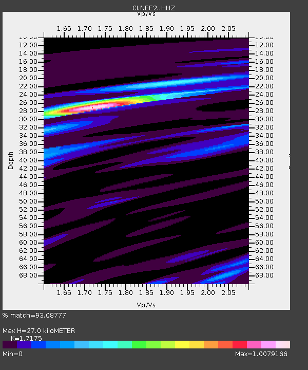
NEE2 Needles Airport - Earthquake Result Viewer
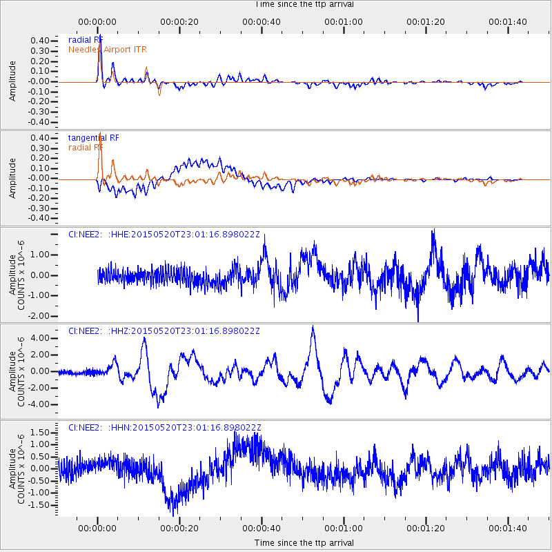
Earthquake location: Santa Cruz Islands Region
Earthquake latitude/longitude: -10.9/164.2
Earthquake time(UTC): 2015/05/20 (140) 22:48:53 GMT
Earthquake Depth: 12 km
Earthquake Magnitude: 6.8 MWW, 6.7 MWB, 6.8 MWC, 6.9 MI
Earthquake Catalog/Contributor: NEIC PDE/NEIC COMCAT
Network: CI Caltech Regional Seismic Network
Station: NEE2 Needles Airport
Lat/Lon: 34.77 N/114.62 W
Elevation: 271 m
Distance: 89.0 deg
Az: 54.462 deg
Baz: 256.136 deg
Ray Param: 0.04214082
Estimated Moho Depth: 27.0 km
Estimated Crust Vp/Vs: 1.72
Assumed Crust Vp: 6.276 km/s
Estimated Crust Vs: 3.654 km/s
Estimated Crust Poisson's Ratio: 0.24
Radial Match: 93.08777 %
Radial Bump: 400
Transverse Match: 64.94884 %
Transverse Bump: 400
SOD ConfigId: 7422571
Insert Time: 2019-04-18 23:51:22.461 +0000
GWidth: 2.5
Max Bumps: 400
Tol: 0.001

Signal To Noise

ChannelStoNSTALTA
CI:NEE2: :HHZ:20150520T23:01:16.898022Z4.6666997.6705095E-71.6436694E-7
CI:NEE2: :HHN:20150520T23:01:16.898022Z1.39047033.251983E-72.3387649E-7
CI:NEE2: :HHE:20150520T23:01:16.898022Z1.49878934.3353194E-72.8925476E-7
Arrivals
Ps3.2 SECOND
PpPs11 SECOND
PsPs/PpSs15 SECOND