You are here: Home > Network List > IU - Global Seismograph Network (GSN - IRIS/USGS) Stations List
> Station PMG Port Moresby, New Guinea > Earthquake Result Viewer
PMG Port Moresby, New Guinea - Earthquake Result Viewer
| Earthquake location: |
Tonga Islands |
| Earthquake latitude/longitude: |
-15.3/-173.1 |
| Earthquake time(UTC): |
1996/08/05 (218) 02:08:58 GMT |
| Earthquake Depth: |
41 km |
| Earthquake Magnitude: |
6.0 MB, 6.7 MS, 6.7 UNKNOWN, 6.2 ME |
| Earthquake Catalog/Contributor: |
WHDF/NEIC |
|
| Network: |
IU Global Seismograph Network (GSN - IRIS/USGS) |
| Station: |
PMG Port Moresby, New Guinea |
| Lat/Lon: |
9.41 S/147.15 E |
| Elevation: |
67 m |
|
| Distance: |
39.2 deg |
| Az: |
273.796 deg |
| Baz: |
102.579 deg |
| Ray Param: |
0.07503243 |
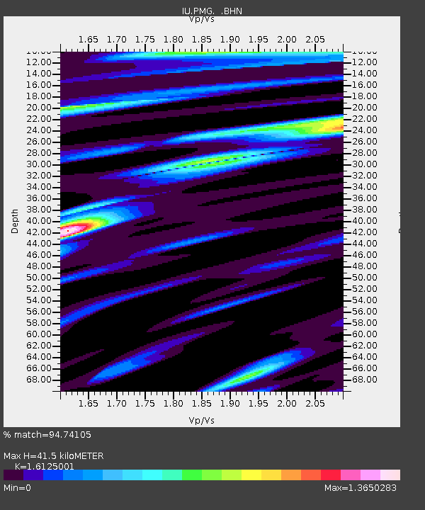
| Estimated Moho Depth: |
41.5 km |
| Estimated Crust Vp/Vs: |
1.61 |
| Assumed Crust Vp: |
6.122 km/s |
| Estimated Crust Vs: |
3.797 km/s |
| Estimated Crust Poisson's Ratio: |
0.19 |
|
| Radial Match: |
94.74105 % |
| Radial Bump: |
335 |
| Transverse Match: |
78.39623 % |
| Transverse Bump: |
400 |
| SOD ConfigId: |
6273 |
| Insert Time: |
2010-03-02 15:13:15.822 +0000 |
| GWidth: |
2.5 |
| Max Bumps: |
400 |
| Tol: |
0.001 |
|
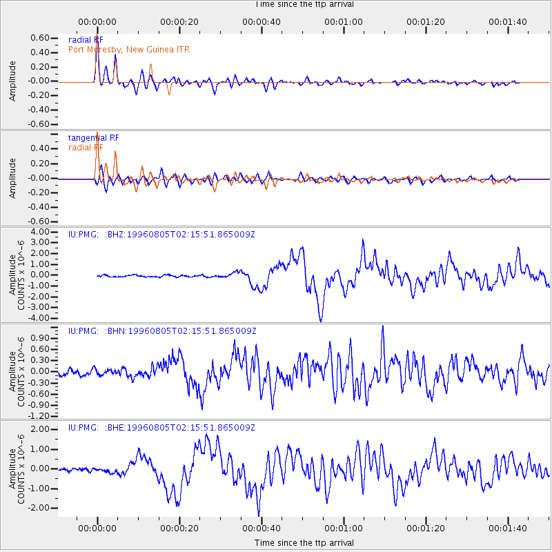
Signal To Noise
| Channel | StoN | STA | LTA |
| IU:PMG: :BHN:19960805T02:15:51.865009Z | 1.0739645 | 9.4014595E-8 | 8.753976E-8 |
| IU:PMG: :BHE:19960805T02:15:51.865009Z | 1.6216694 | 1.0747038E-7 | 6.627145E-8 |
| IU:PMG: :BHZ:19960805T02:15:51.865009Z | 3.4011118 | 2.581927E-7 | 7.591421E-8 |
| Arrivals |
| Ps | 4.5 SECOND |
| PpPs | 16 SECOND |
| PsPs/PpSs | 21 SECOND |


