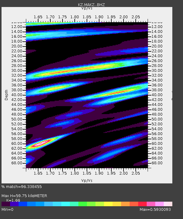
MAKZ Makanchi, Kazakstan - Earthquake Result Viewer

Earthquake location: Santa Cruz Islands Region
Earthquake latitude/longitude: -10.9/164.2
Earthquake time(UTC): 2015/05/20 (140) 22:48:53 GMT
Earthquake Depth: 12 km
Earthquake Magnitude: 6.8 MWW, 6.7 MWB, 6.8 MWC, 6.9 MI
Earthquake Catalog/Contributor: NEIC PDE/NEIC COMCAT
Network: KZ Kazakhstan Network
Station: MAKZ Makanchi, Kazakstan
Lat/Lon: 46.81 N/81.98 E
Elevation: 600 m
Distance: 92.6 deg
Az: 317.064 deg
Baz: 103.077 deg
Ray Param: 0.04143405
Estimated Moho Depth: 59.75 km
Estimated Crust Vp/Vs: 1.66
Assumed Crust Vp: 6.571 km/s
Estimated Crust Vs: 3.958 km/s
Estimated Crust Poisson's Ratio: 0.22
Radial Match: 96.338455 %
Radial Bump: 304
Transverse Match: 85.35679 %
Transverse Bump: 400
SOD ConfigId: 7422571
Insert Time: 2019-04-18 23:52:39.881 +0000
GWidth: 2.5
Max Bumps: 400
Tol: 0.001

Signal To Noise

ChannelStoNSTALTA
KZ:MAKZ: :BHZ:20150520T23:01:33.325024Z4.2936741.697011E-73.9523517E-8
KZ:MAKZ: :BHN:20150520T23:01:33.325024Z1.1973392.4415082E-82.0391118E-8
KZ:MAKZ: :BHE:20150520T23:01:33.325024Z1.95004214.1049518E-82.1050582E-8
Arrivals
Ps6.1 SECOND
PpPs24 SECOND
PsPs/PpSs30 SECOND