You are here: Home > Network List > KZ - Kazakhstan Network Stations List
> Station MKAR Makanchi array,MK31, Kazakhstan > Earthquake Result Viewer
MKAR Makanchi array,MK31, Kazakhstan - Earthquake Result Viewer
| Earthquake location: |
Santa Cruz Islands Region |
| Earthquake latitude/longitude: |
-10.9/164.2 |
| Earthquake time(UTC): |
2015/05/20 (140) 22:48:53 GMT |
| Earthquake Depth: |
12 km |
| Earthquake Magnitude: |
6.8 MWW, 6.7 MWB, 6.8 MWC, 6.9 MI |
| Earthquake Catalog/Contributor: |
NEIC PDE/NEIC COMCAT |
|
| Network: |
KZ Kazakhstan Network |
| Station: |
MKAR Makanchi array,MK31, Kazakhstan |
| Lat/Lon: |
46.79 N/82.29 E |
| Elevation: |
615 m |
|
| Distance: |
92.3 deg |
| Az: |
317.099 deg |
| Baz: |
103.303 deg |
| Ray Param: |
0.041471697 |
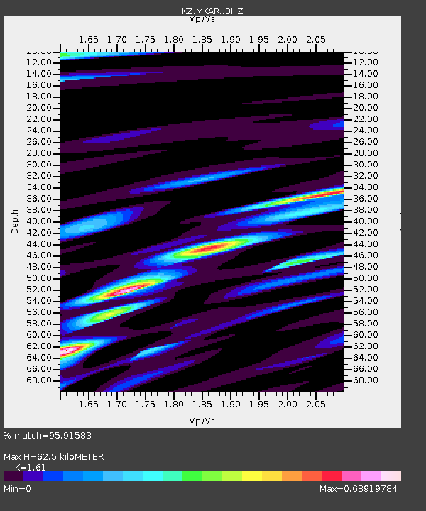
| Estimated Moho Depth: |
62.5 km |
| Estimated Crust Vp/Vs: |
1.61 |
| Assumed Crust Vp: |
6.688 km/s |
| Estimated Crust Vs: |
4.154 km/s |
| Estimated Crust Poisson's Ratio: |
0.19 |
|
| Radial Match: |
95.91583 % |
| Radial Bump: |
400 |
| Transverse Match: |
93.18329 % |
| Transverse Bump: |
400 |
| SOD ConfigId: |
7422571 |
| Insert Time: |
2019-04-18 23:52:40.520 +0000 |
| GWidth: |
2.5 |
| Max Bumps: |
400 |
| Tol: |
0.001 |
|

Signal To Noise
| Channel | StoN | STA | LTA |
| KZ:MKAR: :BHZ:20150520T23:01:32.351025Z | 8.735999 | 6.011464E-7 | 6.8812554E-8 |
| KZ:MKAR: :BHN:20150520T23:01:32.351025Z | 1.1942914 | 3.609345E-8 | 3.0221646E-8 |
| KZ:MKAR: :BHE:20150520T23:01:32.351025Z | 4.7042303 | 1.4861749E-7 | 3.1592307E-8 |
| Arrivals |
| Ps | 5.8 SECOND |
| PpPs | 24 SECOND |
| PsPs/PpSs | 30 SECOND |


