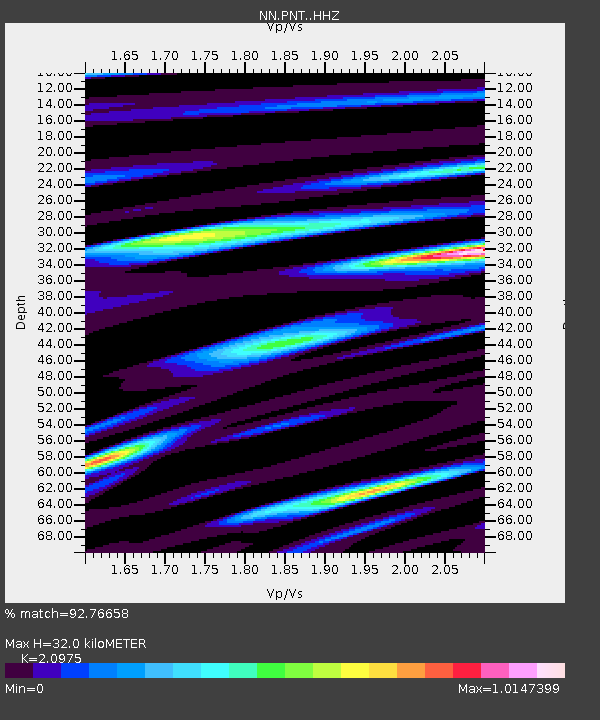
PNT Pine Nut, Nevada w84 - Earthquake Result Viewer

Earthquake location: Santa Cruz Islands Region
Earthquake latitude/longitude: -10.9/164.2
Earthquake time(UTC): 2015/05/20 (140) 22:48:53 GMT
Earthquake Depth: 12 km
Earthquake Magnitude: 6.8 MWW, 6.7 MWB, 6.8 MWC, 6.9 MI
Earthquake Catalog/Contributor: NEIC PDE/NEIC COMCAT
Network: NN Western Great Basin/Eastern Sierra Nevada
Station: PNT Pine Nut, Nevada w84
Lat/Lon: 39.09 N/119.60 W
Elevation: 2076 m
Distance: 86.3 deg
Az: 49.24 deg
Baz: 252.941 deg
Ray Param: 0.044122044
Estimated Moho Depth: 32.0 km
Estimated Crust Vp/Vs: 2.10
Assumed Crust Vp: 6.279 km/s
Estimated Crust Vs: 2.993 km/s
Estimated Crust Poisson's Ratio: 0.35
Radial Match: 92.76658 %
Radial Bump: 400
Transverse Match: 73.23254 %
Transverse Bump: 400
SOD ConfigId: 7422571
Insert Time: 2019-04-18 23:52:53.347 +0000
GWidth: 2.5
Max Bumps: 400
Tol: 0.001

Signal To Noise

ChannelStoNSTALTA
NN:PNT: :HHZ:20150520T23:01:03.979993Z12.5909988.0361383E-76.382447E-8
NN:PNT: :HHN:20150520T23:01:03.979993Z1.3248669.225973E-86.9637025E-8
NN:PNT: :HHE:20150520T23:01:03.979993Z2.52016042.470373E-79.802443E-8
Arrivals
Ps5.7 SECOND
PpPs15 SECOND
PsPs/PpSs21 SECOND