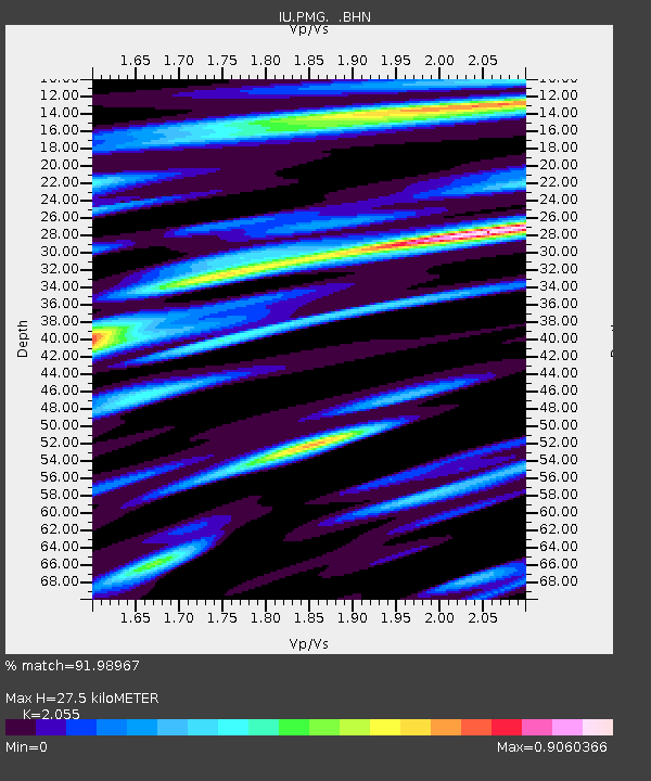
PMG Port Moresby, New Guinea - Earthquake Result Viewer
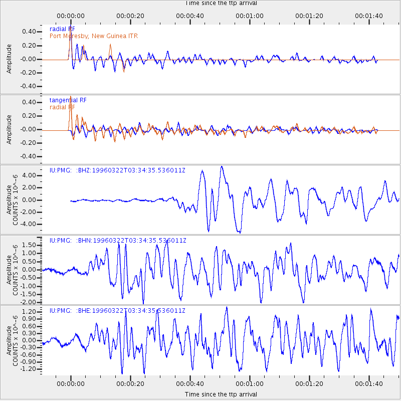
Earthquake location: Rat Islands, Aleutian Islands
Earthquake latitude/longitude: 51.2/178.7
Earthquake time(UTC): 1996/03/22 (082) 03:24:20 GMT
Earthquake Depth: 20 km
Earthquake Magnitude: 5.7 MB, 6.6 MS, 6.8 UNKNOWN, 6.6 ML
Earthquake Catalog/Contributor: WHDF/NEIC
Network: IU Global Seismograph Network (GSN - IRIS/USGS)
Station: PMG Port Moresby, New Guinea
Lat/Lon: 9.41 S/147.15 E
Elevation: 67 m
Distance: 66.3 deg
Az: 214.324 deg
Baz: 21.062 deg
Ray Param: 0.05771106
Estimated Moho Depth: 27.5 km
Estimated Crust Vp/Vs: 2.06
Assumed Crust Vp: 6.122 km/s
Estimated Crust Vs: 2.979 km/s
Estimated Crust Poisson's Ratio: 0.34
Radial Match: 91.98967 %
Radial Bump: 400
Transverse Match: 80.822136 %
Transverse Bump: 400
SOD ConfigId: 6273
Insert Time: 2010-03-02 15:13:36.531 +0000
GWidth: 2.5
Max Bumps: 400
Tol: 0.001

Signal To Noise

ChannelStoNSTALTA
IU:PMG: :BHN:19960322T03:34:35.536011Z1.29218591.2886126E-79.9723465E-8
IU:PMG: :BHE:19960322T03:34:35.536011Z2.86791681.8144037E-76.326556E-8
IU:PMG: :BHZ:19960322T03:34:35.536011Z2.2966112.4597796E-71.0710475E-7
Arrivals
Ps4.9 SECOND
PpPs13 SECOND
PsPs/PpSs18 SECOND