You are here: Home > Network List > TA - USArray Transportable Network (new EarthScope stations) Stations List
> Station 109C Camp Elliot, Mirimar, CA, USA > Earthquake Result Viewer
109C Camp Elliot, Mirimar, CA, USA - Earthquake Result Viewer
| Earthquake location: |
Santa Cruz Islands Region |
| Earthquake latitude/longitude: |
-10.9/164.2 |
| Earthquake time(UTC): |
2015/05/20 (140) 22:48:53 GMT |
| Earthquake Depth: |
12 km |
| Earthquake Magnitude: |
6.8 MWW, 6.7 MWB, 6.8 MWC, 6.9 MI |
| Earthquake Catalog/Contributor: |
NEIC PDE/NEIC COMCAT |
|
| Network: |
TA USArray Transportable Network (new EarthScope stations) |
| Station: |
109C Camp Elliot, Mirimar, CA, USA |
| Lat/Lon: |
32.89 N/117.11 W |
| Elevation: |
150 m |
|
| Distance: |
86.6 deg |
| Az: |
55.758 deg |
| Baz: |
254.807 deg |
| Ray Param: |
0.043959536 |
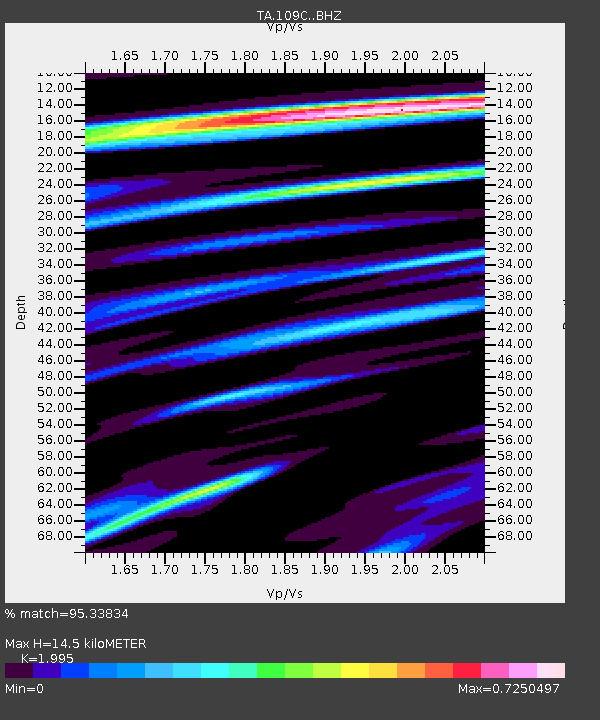
| Estimated Moho Depth: |
14.5 km |
| Estimated Crust Vp/Vs: |
2.00 |
| Assumed Crust Vp: |
6.264 km/s |
| Estimated Crust Vs: |
3.14 km/s |
| Estimated Crust Poisson's Ratio: |
0.33 |
|
| Radial Match: |
95.33834 % |
| Radial Bump: |
400 |
| Transverse Match: |
80.90329 % |
| Transverse Bump: |
400 |
| SOD ConfigId: |
7422571 |
| Insert Time: |
2019-04-18 23:53:43.818 +0000 |
| GWidth: |
2.5 |
| Max Bumps: |
400 |
| Tol: |
0.001 |
|

Signal To Noise
| Channel | StoN | STA | LTA |
| TA:109C: :BHZ:20150520T23:01:05.068982Z | 4.374118 | 7.9778164E-7 | 1.8238686E-7 |
| TA:109C: :BHN:20150520T23:01:05.068982Z | 0.9039612 | 1.0422794E-7 | 1.1530135E-7 |
| TA:109C: :BHE:20150520T23:01:05.068982Z | 2.068617 | 2.6627103E-7 | 1.2871934E-7 |
| Arrivals |
| Ps | 2.3 SECOND |
| PpPs | 6.8 SECOND |
| PsPs/PpSs | 9.1 SECOND |


