You are here: Home > Network List > UW - Pacific Northwest Regional Seismic Network Stations List
> Station BABR Baber Butte, OR, USA > Earthquake Result Viewer
BABR Baber Butte, OR, USA - Earthquake Result Viewer
| Earthquake location: |
Santa Cruz Islands Region |
| Earthquake latitude/longitude: |
-10.9/164.2 |
| Earthquake time(UTC): |
2015/05/20 (140) 22:48:53 GMT |
| Earthquake Depth: |
12 km |
| Earthquake Magnitude: |
6.8 MWW, 6.7 MWB, 6.8 MWC, 6.9 MI |
| Earthquake Catalog/Contributor: |
NEIC PDE/NEIC COMCAT |
|
| Network: |
UW Pacific Northwest Regional Seismic Network |
| Station: |
BABR Baber Butte, OR, USA |
| Lat/Lon: |
44.62 N/123.79 W |
| Elevation: |
439 m |
|
| Distance: |
85.1 deg |
| Az: |
42.986 deg |
| Baz: |
249.687 deg |
| Ray Param: |
0.044976547 |
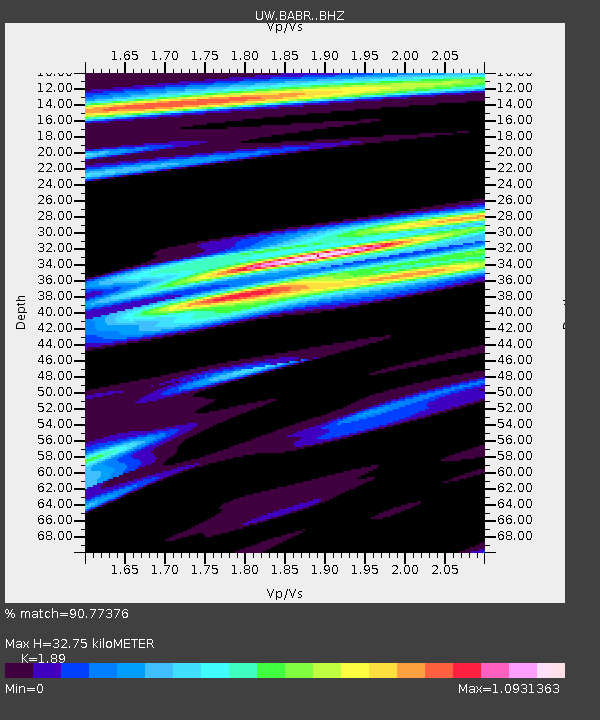
| Estimated Moho Depth: |
32.75 km |
| Estimated Crust Vp/Vs: |
1.89 |
| Assumed Crust Vp: |
6.566 km/s |
| Estimated Crust Vs: |
3.474 km/s |
| Estimated Crust Poisson's Ratio: |
0.31 |
|
| Radial Match: |
90.77376 % |
| Radial Bump: |
400 |
| Transverse Match: |
68.934685 % |
| Transverse Bump: |
400 |
| SOD ConfigId: |
7422571 |
| Insert Time: |
2019-04-18 23:55:05.655 +0000 |
| GWidth: |
2.5 |
| Max Bumps: |
400 |
| Tol: |
0.001 |
|

Signal To Noise
| Channel | StoN | STA | LTA |
| UW:BABR: :BHZ:20150520T23:00:58.104993Z | 2.1278422 | 9.2178664E-7 | 4.3320253E-7 |
| UW:BABR: :BHN:20150520T23:00:58.104993Z | 0.8048665 | 3.7333788E-7 | 4.6385065E-7 |
| UW:BABR: :BHE:20150520T23:00:58.104993Z | 1.3488168 | 5.469543E-7 | 4.055067E-7 |
| Arrivals |
| Ps | 4.5 SECOND |
| PpPs | 14 SECOND |
| PsPs/PpSs | 19 SECOND |


