You are here: Home > Network List > UW - Pacific Northwest Regional Seismic Network Stations List
> Station KENT Carlson Farm, Grass Valley, OR, USA > Earthquake Result Viewer
KENT Carlson Farm, Grass Valley, OR, USA - Earthquake Result Viewer
| Earthquake location: |
Santa Cruz Islands Region |
| Earthquake latitude/longitude: |
-10.9/164.2 |
| Earthquake time(UTC): |
2015/05/20 (140) 22:48:53 GMT |
| Earthquake Depth: |
12 km |
| Earthquake Magnitude: |
6.8 MWW, 6.7 MWB, 6.8 MWC, 6.9 MI |
| Earthquake Catalog/Contributor: |
NEIC PDE/NEIC COMCAT |
|
| Network: |
UW Pacific Northwest Regional Seismic Network |
| Station: |
KENT Carlson Farm, Grass Valley, OR, USA |
| Lat/Lon: |
45.24 N/120.64 W |
| Elevation: |
780 m |
|
| Distance: |
87.5 deg |
| Az: |
43.143 deg |
| Baz: |
251.917 deg |
| Ray Param: |
0.04330986 |
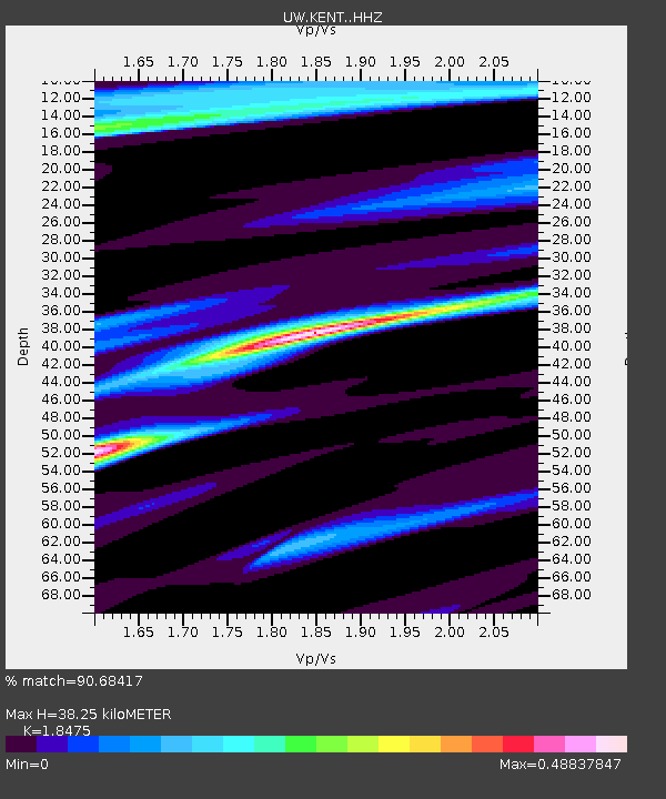
| Estimated Moho Depth: |
38.25 km |
| Estimated Crust Vp/Vs: |
1.85 |
| Assumed Crust Vp: |
6.597 km/s |
| Estimated Crust Vs: |
3.571 km/s |
| Estimated Crust Poisson's Ratio: |
0.29 |
|
| Radial Match: |
90.68417 % |
| Radial Bump: |
370 |
| Transverse Match: |
86.72453 % |
| Transverse Bump: |
376 |
| SOD ConfigId: |
7422571 |
| Insert Time: |
2019-04-18 23:55:16.441 +0000 |
| GWidth: |
2.5 |
| Max Bumps: |
400 |
| Tol: |
0.001 |
|
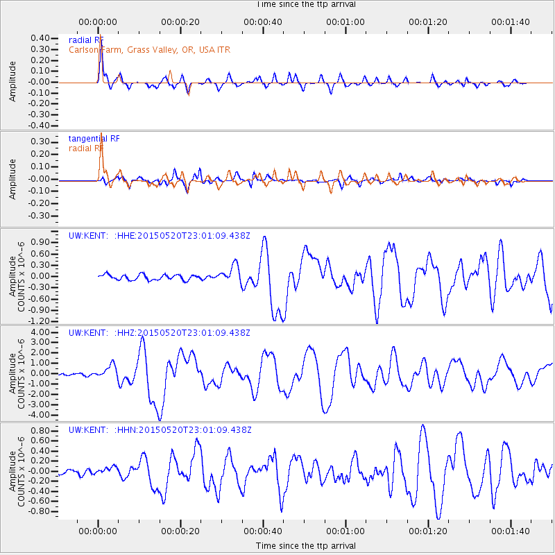
Signal To Noise
| Channel | StoN | STA | LTA |
| UW:KENT: :HHZ:20150520T23:01:09.438Z | 8.970751 | 6.695544E-7 | 7.46375E-8 |
| UW:KENT: :HHN:20150520T23:01:09.438Z | 1.0031818 | 8.626649E-8 | 8.599287E-8 |
| UW:KENT: :HHE:20150520T23:01:09.438Z | 3.2749128 | 2.2729238E-7 | 6.94041E-8 |
| Arrivals |
| Ps | 5.0 SECOND |
| PpPs | 16 SECOND |
| PsPs/PpSs | 21 SECOND |


