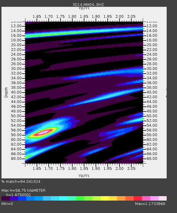
MM04 "Mount St Helens, WA" - Earthquake Result Viewer

Earthquake location: Santa Cruz Islands Region
Earthquake latitude/longitude: -10.9/164.2
Earthquake time(UTC): 2015/05/20 (140) 22:48:53 GMT
Earthquake Depth: 12 km
Earthquake Magnitude: 6.8 MWW, 6.7 MWB, 6.8 MWC, 6.9 MI
Earthquake Catalog/Contributor: NEIC PDE/NEIC COMCAT
Network: XD Illuminating the architecture of the greater Mount St. Helens magmatic systems f
Station: MM04 "Mount St Helens, WA"
Lat/Lon: 46.02 N/122.35 W
Elevation: 313 m
Distance: 86.6 deg
Az: 42.018 deg
Baz: 250.64 deg
Ray Param: 0.04395365
Estimated Moho Depth: 56.75 km
Estimated Crust Vp/Vs: 1.68
Assumed Crust Vp: 6.566 km/s
Estimated Crust Vs: 3.92 km/s
Estimated Crust Poisson's Ratio: 0.22
Radial Match: 94.041824 %
Radial Bump: 400
Transverse Match: 89.06491 %
Transverse Bump: 400
SOD ConfigId: 7422571
Insert Time: 2019-04-18 23:56:16.949 +0000
GWidth: 2.5
Max Bumps: 400
Tol: 0.001

Signal To Noise

ChannelStoNSTALTA
XD:MM04: :BHZ:20150520T23:01:05.159985Z8.462717.4909474E-78.851712E-8
XD:MM04: :BHN:20150520T23:01:05.159985Z2.6844141.7354917E-76.465067E-8
XD:MM04: :BHE:20150520T23:01:05.159985Z1.95684791.8883895E-79.65016E-8
Arrivals
Ps6.0 SECOND
PpPs23 SECOND
PsPs/PpSs29 SECOND