PMG Port Moresby, New Guinea - Earthquake Result Viewer
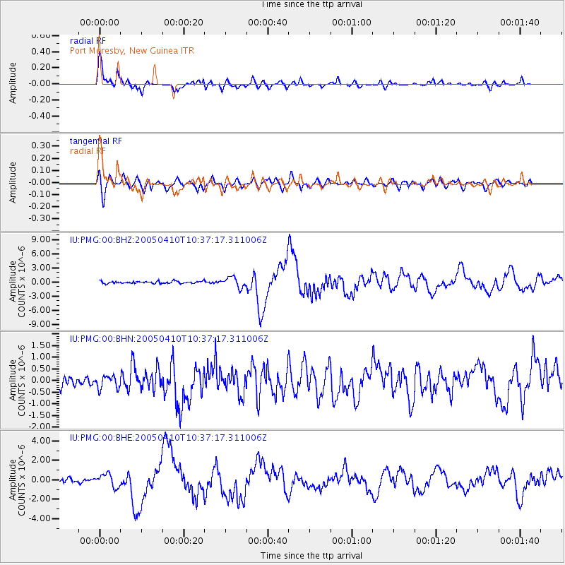
Earthquake location: Southern Sumatra, Indonesia
Earthquake latitude/longitude: -1.6/99.6
Earthquake time(UTC): 2005/04/10 (100) 10:29:11 GMT
Earthquake Depth: 19 km
Earthquake Magnitude: 6.4 MB, 6.7 MS, 6.7 MW, 6.6 MW
Earthquake Catalog/Contributor: WHDF/NEIC
Network: IU Global Seismograph Network (GSN - IRIS/USGS)
Station: PMG Port Moresby, New Guinea
Lat/Lon: 9.41 S/147.15 E
Elevation: 67 m
Distance: 47.9 deg
Az: 101.141 deg
Baz: 276.303 deg
Ray Param: 0.06967383
Estimated Moho Depth: 34.25 km
Estimated Crust Vp/Vs: 1.73
Assumed Crust Vp: 6.122 km/s
Estimated Crust Vs: 3.534 km/s
Estimated Crust Poisson's Ratio: 0.25
Radial Match: 92.46545 %
Radial Bump: 400
Transverse Match: 82.49213 %
Transverse Bump: 400
SOD ConfigId: 2459
Insert Time: 2010-03-02 15:14:28.392 +0000
GWidth: 2.5
Max Bumps: 400
Tol: 0.001

Signal To Noise

ChannelStoNSTALTA
IU:PMG:00:BHN:20050410T10:37:17.311006Z1.49520712.7827457E-71.8611105E-7
IU:PMG:00:BHE:20050410T10:37:17.311006Z3.73739586.8616316E-71.8359394E-7
IU:PMG:00:BHZ:20050410T10:37:17.311006Z4.8052491.1069105E-62.3035443E-7
Arrivals
Ps4.3 SECOND
PpPs14 SECOND
PsPs/PpSs19 SECOND