PMG Port Moresby, New Guinea - Earthquake Result Viewer
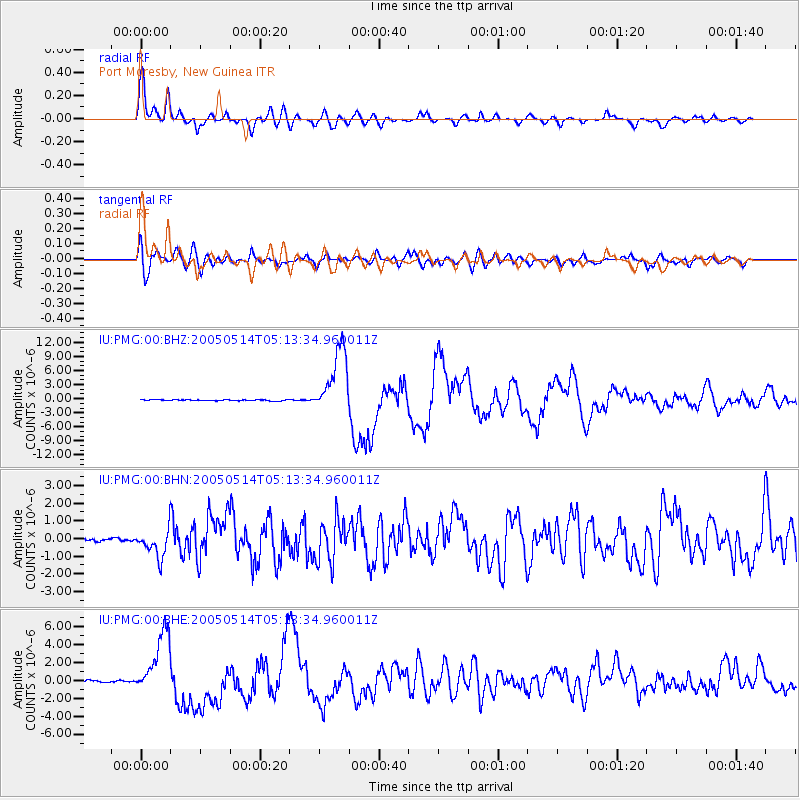
Earthquake location: Northern Sumatra, Indonesia
Earthquake latitude/longitude: 0.6/98.5
Earthquake time(UTC): 2005/05/14 (134) 05:05:18 GMT
Earthquake Depth: 34 km
Earthquake Magnitude: 6.4 MB, 6.8 MS, 6.8 MW, 6.8 MW
Earthquake Catalog/Contributor: WHDF/NEIC
Network: IU Global Seismograph Network (GSN - IRIS/USGS)
Station: PMG Port Moresby, New Guinea
Lat/Lon: 9.41 S/147.15 E
Elevation: 67 m
Distance: 49.5 deg
Az: 102.847 deg
Baz: 278.871 deg
Ray Param: 0.0686039
Estimated Moho Depth: 32.75 km
Estimated Crust Vp/Vs: 1.80
Assumed Crust Vp: 6.122 km/s
Estimated Crust Vs: 3.401 km/s
Estimated Crust Poisson's Ratio: 0.28
Radial Match: 91.883446 %
Radial Bump: 400
Transverse Match: 78.68628 %
Transverse Bump: 400
SOD ConfigId: 2455
Insert Time: 2010-03-02 15:14:32.001 +0000
GWidth: 2.5
Max Bumps: 400
Tol: 0.001

Signal To Noise

ChannelStoNSTALTA
IU:PMG:00:BHN:20050514T05:13:34.960011Z11.2401427.7647223E-76.9080286E-8
IU:PMG:00:BHE:20050514T05:13:34.960011Z34.1933443.4976208E-61.0228952E-7
IU:PMG:00:BHZ:20050514T05:13:34.960011Z58.041757.0088477E-61.2075527E-7
Arrivals
Ps4.5 SECOND
PpPs14 SECOND
PsPs/PpSs19 SECOND