You are here: Home > Network List > IU - Global Seismograph Network (GSN - IRIS/USGS) Stations List
> Station PMG Port Moresby, New Guinea > Earthquake Result Viewer
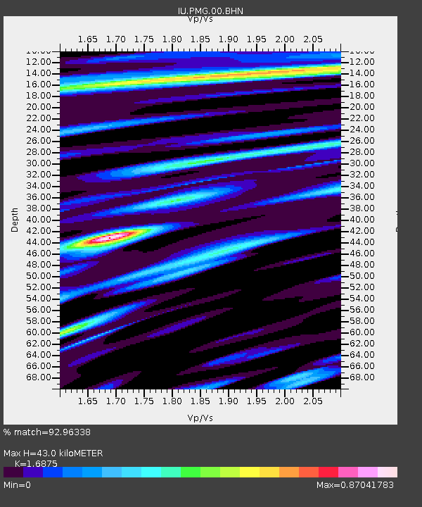
PMG Port Moresby, New Guinea - Earthquake Result Viewer
| Earthquake location: |
Pakistan |
| Earthquake latitude/longitude: |
34.5/73.6 |
| Earthquake time(UTC): |
2005/10/08 (281) 03:50:40 GMT |
| Earthquake Depth: |
26 km |
| Earthquake Magnitude: |
6.9 MB, 7.7 MS, 7.6 MW, 7.3 MW |
| Earthquake Catalog/Contributor: |
WHDF/NEIC |
|
| Network: |
IU Global Seismograph Network (GSN - IRIS/USGS) |
| Station: |
PMG Port Moresby, New Guinea |
| Lat/Lon: |
9.41 S/147.15 E |
| Elevation: |
67 m |
|
| Distance: |
82.0 deg |
| Az: |
107.126 deg |
| Baz: |
306.915 deg |
| Ray Param: |
0.047145348 |
| Estimated Moho Depth: |
43.0 km |
| Estimated Crust Vp/Vs: |
1.69 |
| Assumed Crust Vp: |
6.122 km/s |
| Estimated Crust Vs: |
3.628 km/s |
| Estimated Crust Poisson's Ratio: |
0.23 |
|
| Radial Match: |
92.96338 % |
| Radial Bump: |
400 |
| Transverse Match: |
89.76454 % |
| Transverse Bump: |
400 |
| SOD ConfigId: |
2475 |
| Insert Time: |
2010-03-02 15:14:37.922 +0000 |
| GWidth: |
2.5 |
| Max Bumps: |
400 |
| Tol: |
0.001 |
|

Signal To Noise
| Channel | StoN | STA | LTA |
| IU:PMG:00:BHN:20051008T04:02:27.234998Z | 13.757113 | 1.5856535E-6 | 1.1526063E-7 |
| IU:PMG:00:BHE:20051008T04:02:27.234998Z | 15.269074 | 1.554287E-6 | 1.01793134E-7 |
| IU:PMG:00:BHZ:20051008T04:02:27.234998Z | 50.841965 | 6.6254593E-6 | 1.3031477E-7 |
| Arrivals |
| Ps | 5.0 SECOND |
| PpPs | 18 SECOND |
| PsPs/PpSs | 23 SECOND |


