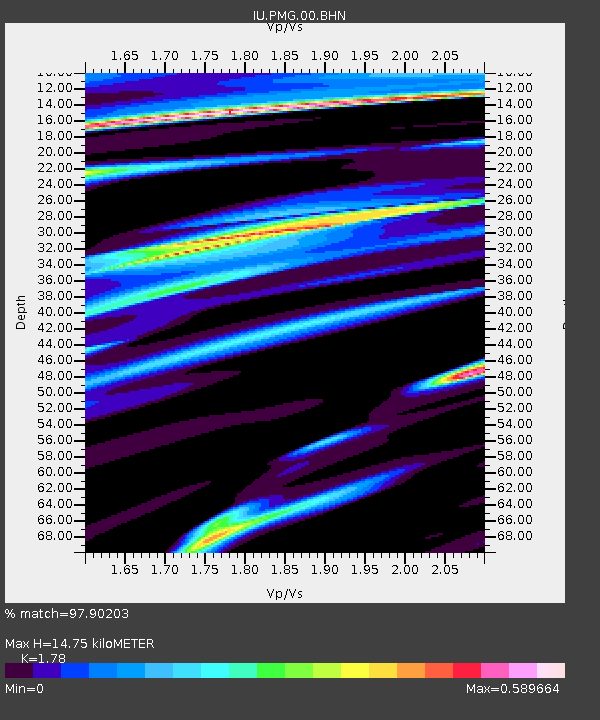
PMG Port Moresby, New Guinea - Earthquake Result Viewer
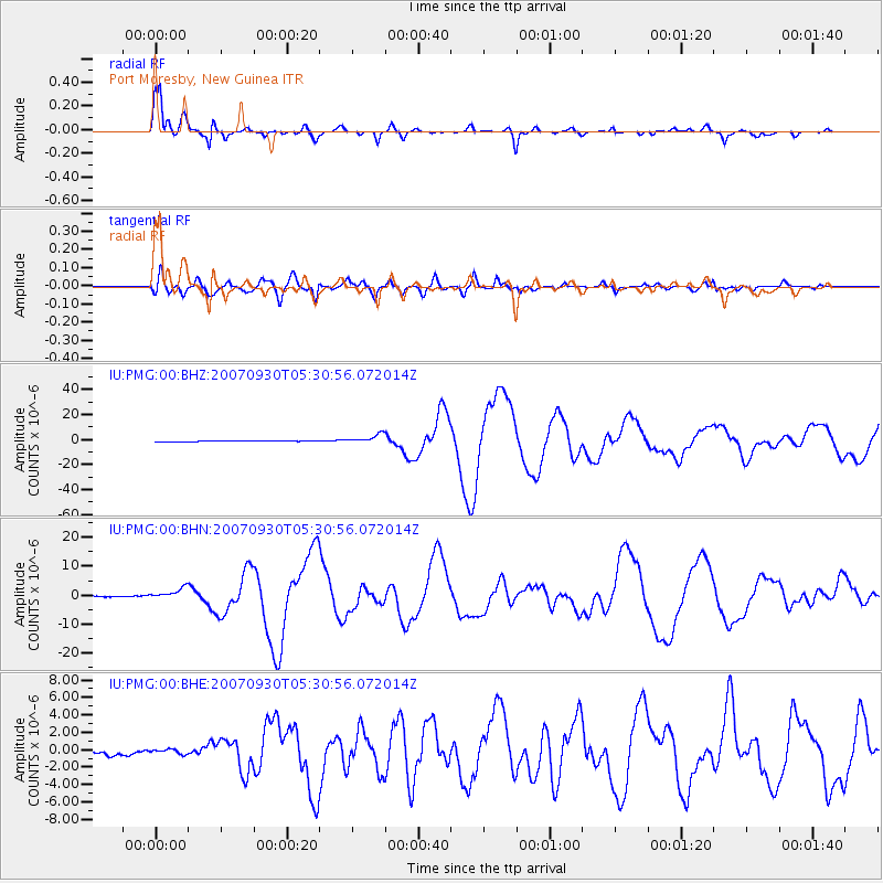
Earthquake location: Auckland Islands, N.Z. Region
Earthquake latitude/longitude: -49.3/164.1
Earthquake time(UTC): 2007/09/30 (273) 05:23:34 GMT
Earthquake Depth: 10 km
Earthquake Magnitude: 6.4 MB, 7.4 MS, 7.4 MW, 6.9 MW
Earthquake Catalog/Contributor: WHDF/NEIC
Network: IU Global Seismograph Network (GSN - IRIS/USGS)
Station: PMG Port Moresby, New Guinea
Lat/Lon: 9.41 S/147.15 E
Elevation: 67 m
Distance: 42.2 deg
Az: 334.621 deg
Baz: 163.47 deg
Ray Param: 0.073316984
Estimated Moho Depth: 14.75 km
Estimated Crust Vp/Vs: 1.78
Assumed Crust Vp: 6.122 km/s
Estimated Crust Vs: 3.439 km/s
Estimated Crust Poisson's Ratio: 0.27
Radial Match: 97.90203 %
Radial Bump: 333
Transverse Match: 91.4937 %
Transverse Bump: 400
SOD ConfigId: 2564
Insert Time: 2010-03-02 15:14:47.222 +0000
GWidth: 2.5
Max Bumps: 400
Tol: 0.001

Signal To Noise

ChannelStoNSTALTA
IU:PMG:00:BHN:20070930T05:30:56.072014Z5.34755471.9738202E-63.6910706E-7
IU:PMG:00:BHE:20070930T05:30:56.072014Z1.15391842.7962523E-72.4232668E-7
IU:PMG:00:BHZ:20070930T05:30:56.072014Z12.7491363.7138939E-62.9130555E-7
Arrivals
Ps2.0 SECOND
PpPs6.3 SECOND
PsPs/PpSs8.3 SECOND