You are here: Home > Network List > IU - Global Seismograph Network (GSN - IRIS/USGS) Stations List
> Station PMG Port Moresby, New Guinea > Earthquake Result Viewer
PMG Port Moresby, New Guinea - Earthquake Result Viewer
| Earthquake location: |
Volcano Islands, Japan Region |
| Earthquake latitude/longitude: |
22.0/142.7 |
| Earthquake time(UTC): |
2007/09/28 (271) 13:38:59 GMT |
| Earthquake Depth: |
276 km |
| Earthquake Magnitude: |
6.7 MB, 7.4 MW, 7.4 MW |
| Earthquake Catalog/Contributor: |
WHDF/NEIC |
|
| Network: |
IU Global Seismograph Network (GSN - IRIS/USGS) |
| Station: |
PMG Port Moresby, New Guinea |
| Lat/Lon: |
9.41 S/147.15 E |
| Elevation: |
67 m |
|
| Distance: |
31.5 deg |
| Az: |
171.481 deg |
| Baz: |
351.991 deg |
| Ray Param: |
0.07813495 |
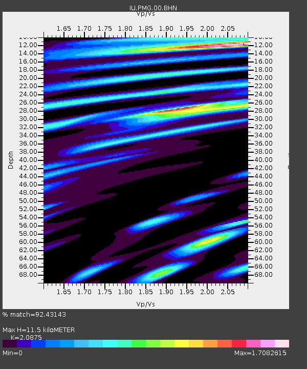
| Estimated Moho Depth: |
11.5 km |
| Estimated Crust Vp/Vs: |
2.09 |
| Assumed Crust Vp: |
6.122 km/s |
| Estimated Crust Vs: |
2.933 km/s |
| Estimated Crust Poisson's Ratio: |
0.35 |
|
| Radial Match: |
92.43143 % |
| Radial Bump: |
400 |
| Transverse Match: |
70.469 % |
| Transverse Bump: |
400 |
| SOD ConfigId: |
2564 |
| Insert Time: |
2010-03-02 15:14:48.357 +0000 |
| GWidth: |
2.5 |
| Max Bumps: |
400 |
| Tol: |
0.001 |
|

Signal To Noise
| Channel | StoN | STA | LTA |
| IU:PMG:00:BHN:20070928T13:44:25.922009Z | 44.91396 | 7.120241E-6 | 1.585307E-7 |
| IU:PMG:00:BHE:20070928T13:44:25.922009Z | 7.1690683 | 2.0488053E-6 | 2.8578404E-7 |
| IU:PMG:00:BHZ:20070928T13:44:25.922009Z | 42.731754 | 1.0172713E-5 | 2.380598E-7 |
| Arrivals |
| Ps | 2.2 SECOND |
| PpPs | 5.5 SECOND |
| PsPs/PpSs | 7.6 SECOND |


