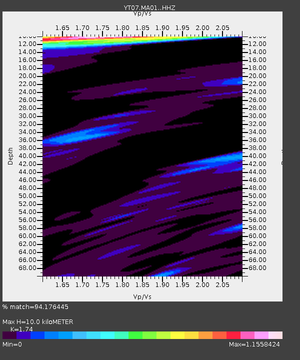
MA01 Polenet mini-array MA01 - Earthquake Result Viewer

Earthquake location: Santa Cruz Islands Region
Earthquake latitude/longitude: -10.9/164.2
Earthquake time(UTC): 2015/05/20 (140) 22:48:53 GMT
Earthquake Depth: 12 km
Earthquake Magnitude: 6.8 MWW, 6.7 MWB, 6.8 MWC, 6.9 MI
Earthquake Catalog/Contributor: NEIC PDE/NEIC COMCAT
Network: YT POLENET
Station: MA01 Polenet mini-array MA01
Lat/Lon: 76.94 S/97.56 W
Elevation: 1345 m
Distance: 81.3 deg
Az: 166.842 deg
Baz: 259.482 deg
Ray Param: 0.047652405
Estimated Moho Depth: 10.0 km
Estimated Crust Vp/Vs: 1.74
Assumed Crust Vp: 5.77 km/s
Estimated Crust Vs: 3.316 km/s
Estimated Crust Poisson's Ratio: 0.25
Radial Match: 94.176445 %
Radial Bump: 331
Transverse Match: 66.53489 %
Transverse Bump: 300
SOD ConfigId: 7422571
Insert Time: 2019-04-18 23:57:18.555 +0000
GWidth: 2.5
Max Bumps: 400
Tol: 0.001

Signal To Noise

ChannelStoNSTALTA
YT:MA01: :HHZ:20150520T23:00:38.289014Z1.8134514.029552E-72.2220352E-7
YT:MA01: :HHN:20150520T23:00:38.289014Z0.6200211.5391512E-72.482418E-7
YT:MA01: :HHE:20150520T23:00:38.289014Z1.13059781.6218344E-71.4344928E-7
Arrivals
Ps1.3 SECOND
PpPs4.6 SECOND
PsPs/PpSs6.0 SECOND