PMG Port Moresby, New Guinea - Earthquake Result Viewer
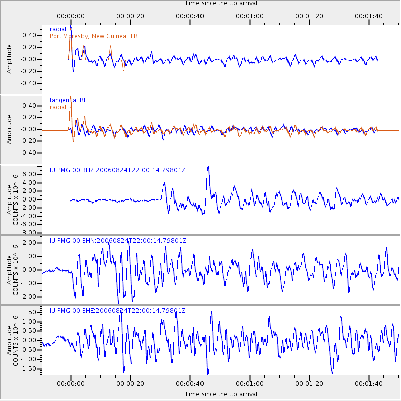
Earthquake location: Near East Coast Of Kamchatka
Earthquake latitude/longitude: 51.1/157.5
Earthquake time(UTC): 2006/08/24 (236) 21:50:36 GMT
Earthquake Depth: 43 km
Earthquake Magnitude: 5.9 MB, 6.2 MS, 6.5 MW, 6.5 MW
Earthquake Catalog/Contributor: WHDF/NEIC
Network: IU Global Seismograph Network (GSN - IRIS/USGS)
Station: PMG Port Moresby, New Guinea
Lat/Lon: 9.41 S/147.15 E
Elevation: 67 m
Distance: 61.0 deg
Az: 191.718 deg
Baz: 7.449 deg
Ray Param: 0.061089024
Estimated Moho Depth: 10.0 km
Estimated Crust Vp/Vs: 1.99
Assumed Crust Vp: 6.122 km/s
Estimated Crust Vs: 3.084 km/s
Estimated Crust Poisson's Ratio: 0.33
Radial Match: 91.9375 %
Radial Bump: 400
Transverse Match: 80.68922 %
Transverse Bump: 400
SOD ConfigId: 2564
Insert Time: 2010-03-02 15:15:42.103 +0000
GWidth: 2.5
Max Bumps: 400
Tol: 0.001

Signal To Noise

ChannelStoNSTALTA
IU:PMG:00:BHN:20060824T22:00:14.79801Z9.0986271.0124376E-61.1127366E-7
IU:PMG:00:BHE:20060824T22:00:14.79801Z2.30031973.992163E-71.7354819E-7
IU:PMG:00:BHZ:20060824T22:00:14.79801Z11.7004822.0572156E-61.7582315E-7
Arrivals
Ps1.7 SECOND
PpPs4.7 SECOND
PsPs/PpSs6.4 SECOND