You are here: Home > Network List > IU - Global Seismograph Network (GSN - IRIS/USGS) Stations List
> Station PMG Port Moresby, New Guinea > Earthquake Result Viewer
PMG Port Moresby, New Guinea - Earthquake Result Viewer
| Earthquake location: |
Fiji Islands Region |
| Earthquake latitude/longitude: |
-19.9/-178.2 |
| Earthquake time(UTC): |
2006/01/02 (002) 22:13:40 GMT |
| Earthquake Depth: |
583 km |
| Earthquake Magnitude: |
6.5 MB, 7.2 MW, 7.1 MW |
| Earthquake Catalog/Contributor: |
WHDF/NEIC |
|
| Network: |
IU Global Seismograph Network (GSN - IRIS/USGS) |
| Station: |
PMG Port Moresby, New Guinea |
| Lat/Lon: |
9.41 S/147.15 E |
| Elevation: |
67 m |
|
| Distance: |
35.1 deg |
| Az: |
282.276 deg |
| Baz: |
111.295 deg |
| Ray Param: |
0.0744795 |
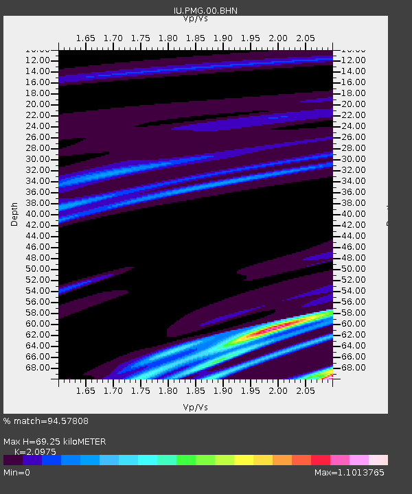
| Estimated Moho Depth: |
69.25 km |
| Estimated Crust Vp/Vs: |
2.10 |
| Assumed Crust Vp: |
6.122 km/s |
| Estimated Crust Vs: |
2.919 km/s |
| Estimated Crust Poisson's Ratio: |
0.35 |
|
| Radial Match: |
94.57808 % |
| Radial Bump: |
132 |
| Transverse Match: |
65.87756 % |
| Transverse Bump: |
330 |
| SOD ConfigId: |
2669 |
| Insert Time: |
2010-03-02 15:16:13.128 +0000 |
| GWidth: |
2.5 |
| Max Bumps: |
400 |
| Tol: |
0.001 |
|
Signal To Noise
| Channel | StoN | STA | LTA |
| IU:PMG:00:BHN:20060102T22:19:15.26301Z | 0.5290619 | 3.1472666E-8 | 5.9487682E-8 |
| IU:PMG:00:BHE:20060102T22:19:15.263987Z | 1.145736 | 5.4591626E-10 | 4.764765E-10 |
| IU:PMG:00:BHZ:20060102T22:19:15.26301Z | 1.0918653 | 3.283719E-10 | 3.0074399E-10 |
| Arrivals |
| Ps | 13 SECOND |
| PpPs | 33 SECOND |
| PsPs/PpSs | 46 SECOND |


