You are here: Home > Network List > AK - Alaska Regional Network Stations List
> Station WAT2 Susitna Watana 2, AK, USA > Earthquake Result Viewer
WAT2 Susitna Watana 2, AK, USA - Earthquake Result Viewer
| Earthquake location: |
Solomon Islands |
| Earthquake latitude/longitude: |
-9.8/160.3 |
| Earthquake time(UTC): |
2015/05/21 (141) 19:32:57 GMT |
| Earthquake Depth: |
10 km |
| Earthquake Magnitude: |
6.0 MWB |
| Earthquake Catalog/Contributor: |
NEIC PDE/NEIC COMCAT |
|
| Network: |
AK Alaska Regional Network |
| Station: |
WAT2 Susitna Watana 2, AK, USA |
| Lat/Lon: |
62.96 N/148.59 W |
| Elevation: |
1366 m |
|
| Distance: |
82.4 deg |
| Az: |
21.024 deg |
| Baz: |
230.696 deg |
| Ray Param: |
0.046939667 |
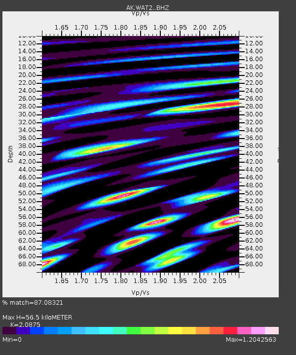
| Estimated Moho Depth: |
56.5 km |
| Estimated Crust Vp/Vs: |
2.09 |
| Assumed Crust Vp: |
6.566 km/s |
| Estimated Crust Vs: |
3.145 km/s |
| Estimated Crust Poisson's Ratio: |
0.35 |
|
| Radial Match: |
87.08321 % |
| Radial Bump: |
400 |
| Transverse Match: |
79.077965 % |
| Transverse Bump: |
400 |
| SOD ConfigId: |
7422571 |
| Insert Time: |
2019-04-19 00:07:11.852 +0000 |
| GWidth: |
2.5 |
| Max Bumps: |
400 |
| Tol: |
0.001 |
|

Signal To Noise
| Channel | StoN | STA | LTA |
| AK:WAT2: :BHZ:20150521T19:44:48.008015Z | 12.4957 | 6.790856E-7 | 5.4345545E-8 |
| AK:WAT2: :BHN:20150521T19:44:48.008015Z | 2.2679634 | 1.486861E-7 | 6.55593E-8 |
| AK:WAT2: :BHE:20150521T19:44:48.008015Z | 4.240581 | 3.3730785E-7 | 7.954284E-8 |
| Arrivals |
| Ps | 9.6 SECOND |
| PpPs | 26 SECOND |
| PsPs/PpSs | 36 SECOND |


