You are here: Home > Network List > IU - Global Seismograph Network (GSN - IRIS/USGS) Stations List
> Station PMG Port Moresby, New Guinea > Earthquake Result Viewer
PMG Port Moresby, New Guinea - Earthquake Result Viewer
| Earthquake location: |
Ryukyu Islands, Japan |
| Earthquake latitude/longitude: |
29.5/129.4 |
| Earthquake time(UTC): |
2000/10/02 (276) 07:44:10 GMT |
| Earthquake Depth: |
33 km |
| Earthquake Magnitude: |
5.6 MB, 5.2 MS, 5.6 MW, 5.5 MW |
| Earthquake Catalog/Contributor: |
WHDF/NEIC |
|
| Network: |
IU Global Seismograph Network (GSN - IRIS/USGS) |
| Station: |
PMG Port Moresby, New Guinea |
| Lat/Lon: |
9.41 S/147.15 E |
| Elevation: |
67 m |
|
| Distance: |
42.3 deg |
| Az: |
153.448 deg |
| Baz: |
336.743 deg |
| Ray Param: |
0.0731829 |
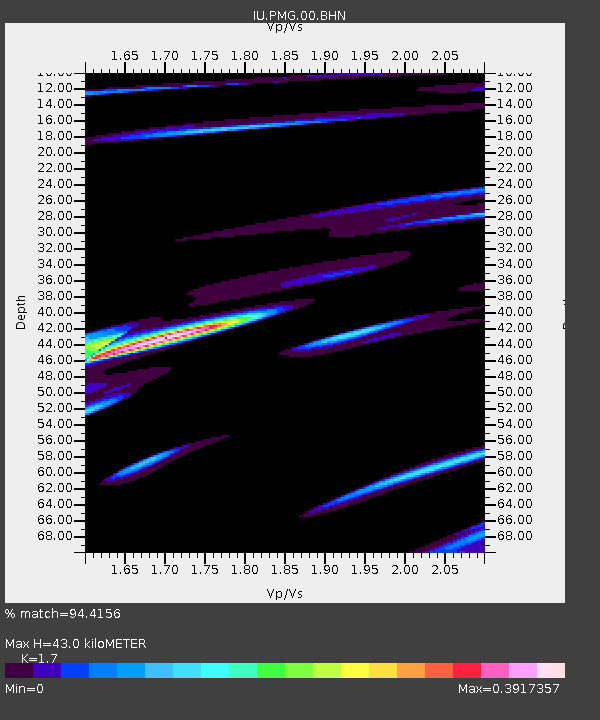
| Estimated Moho Depth: |
43.0 km |
| Estimated Crust Vp/Vs: |
1.70 |
| Assumed Crust Vp: |
6.122 km/s |
| Estimated Crust Vs: |
3.601 km/s |
| Estimated Crust Poisson's Ratio: |
0.24 |
|
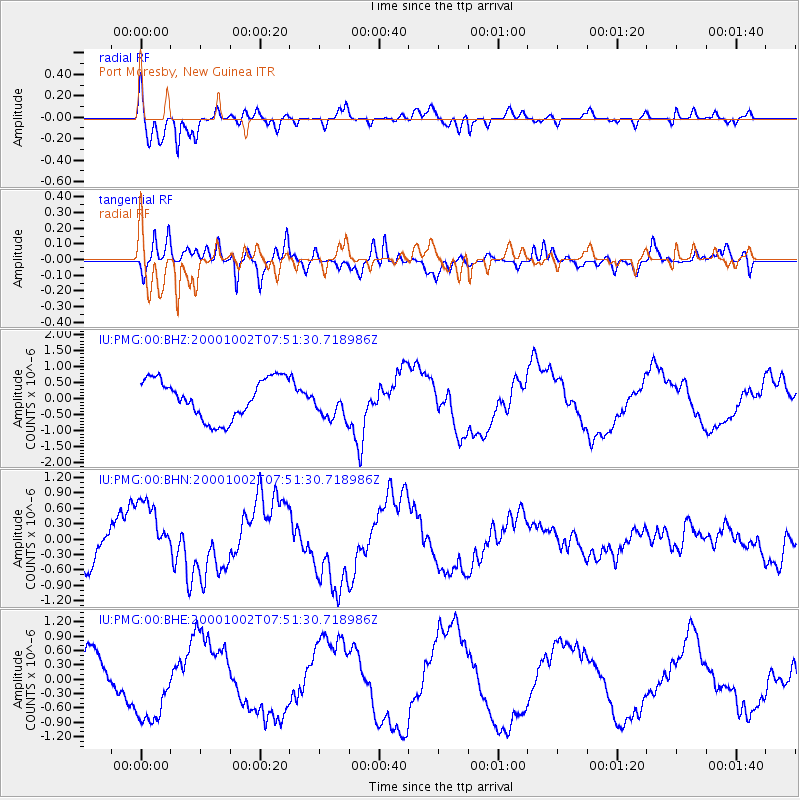
| Radial Match: |
94.4156 % |
| Radial Bump: |
373 |
| Transverse Match: |
91.91254 % |
| Transverse Bump: |
400 |
| SOD ConfigId: |
3753 |
| Insert Time: |
2010-03-02 15:16:25.937 +0000 |
| GWidth: |
2.5 |
| Max Bumps: |
400 |
| Tol: |
0.001 |
|
Signal To Noise
| Channel | StoN | STA | LTA |
| IU:PMG:00:BHN:20001002T07:51:30.718986Z | 1.5001577 | 6.352678E-7 | 4.2346733E-7 |
| IU:PMG:00:BHE:20001002T07:51:30.718986Z | 2.1347005 | 7.7943963E-7 | 3.6512833E-7 |
| IU:PMG:00:BHZ:20001002T07:51:30.718986Z | 0.8473321 | 5.2114217E-7 | 6.1503886E-7 |
| Arrivals |
| Ps | 5.2 SECOND |
| PpPs | 18 SECOND |
| PsPs/PpSs | 23 SECOND |


