You are here: Home > Network List > TA - USArray Transportable Network (new EarthScope stations) Stations List
> Station L04D Klamath Falls, OR, USA > Earthquake Result Viewer
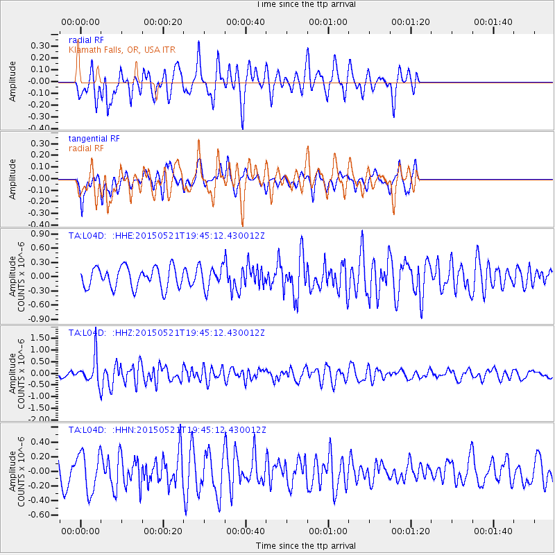
L04D Klamath Falls, OR, USA - Earthquake Result Viewer
*The percent match for this event was below the threshold and hence no stack was calculated.
| Earthquake location: |
Solomon Islands |
| Earthquake latitude/longitude: |
-9.8/160.3 |
| Earthquake time(UTC): |
2015/05/21 (141) 19:32:57 GMT |
| Earthquake Depth: |
10 km |
| Earthquake Magnitude: |
6.0 MWB |
| Earthquake Catalog/Contributor: |
NEIC PDE/NEIC COMCAT |
|
| Network: |
TA USArray Transportable Network (new EarthScope stations) |
| Station: |
L04D Klamath Falls, OR, USA |
| Lat/Lon: |
42.22 N/122.30 W |
| Elevation: |
1437 m |
|
| Distance: |
87.3 deg |
| Az: |
46.524 deg |
| Baz: |
254.339 deg |
| Ray Param: |
$rayparam |
*The percent match for this event was below the threshold and hence was not used in the summary stack. |
|
| Radial Match: |
49.97416 % |
| Radial Bump: |
400 |
| Transverse Match: |
39.71414 % |
| Transverse Bump: |
318 |
| SOD ConfigId: |
7422571 |
| Insert Time: |
2019-04-19 00:11:21.342 +0000 |
| GWidth: |
2.5 |
| Max Bumps: |
400 |
| Tol: |
0.001 |
|
Signal To Noise
| Channel | StoN | STA | LTA |
| TA:L04D: :HHZ:20150521T19:45:12.430012Z | 4.8505287 | 6.093285E-7 | 1.2562104E-7 |
| TA:L04D: :HHN:20150521T19:45:12.430012Z | 1.1686952 | 2.7327889E-7 | 2.3383247E-7 |
| TA:L04D: :HHE:20150521T19:45:12.430012Z | 1.2016517 | 2.6152125E-7 | 2.1763482E-7 |
| Arrivals |
| Ps | |
| PpPs | |
| PsPs/PpSs | |


