You are here: Home > Network List > TA - USArray Transportable Network (new EarthScope stations) Stations List
> Station K27K Chicken, AK, USA > Earthquake Result Viewer
K27K Chicken, AK, USA - Earthquake Result Viewer
| Earthquake location: |
Solomon Islands |
| Earthquake latitude/longitude: |
-9.8/160.3 |
| Earthquake time(UTC): |
2015/05/21 (141) 19:32:57 GMT |
| Earthquake Depth: |
10 km |
| Earthquake Magnitude: |
6.0 MWB |
| Earthquake Catalog/Contributor: |
NEIC PDE/NEIC COMCAT |
|
| Network: |
TA USArray Transportable Network (new EarthScope stations) |
| Station: |
K27K Chicken, AK, USA |
| Lat/Lon: |
64.03 N/142.08 W |
| Elevation: |
389 m |
|
| Distance: |
85.3 deg |
| Az: |
21.898 deg |
| Baz: |
236.608 deg |
| Ray Param: |
0.044829268 |
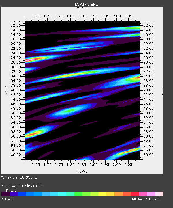
| Estimated Moho Depth: |
27.0 km |
| Estimated Crust Vp/Vs: |
1.60 |
| Assumed Crust Vp: |
6.566 km/s |
| Estimated Crust Vs: |
4.104 km/s |
| Estimated Crust Poisson's Ratio: |
0.18 |
|
| Radial Match: |
88.63645 % |
| Radial Bump: |
313 |
| Transverse Match: |
81.087105 % |
| Transverse Bump: |
382 |
| SOD ConfigId: |
7422571 |
| Insert Time: |
2019-04-19 00:11:20.226 +0000 |
| GWidth: |
2.5 |
| Max Bumps: |
400 |
| Tol: |
0.001 |
|

Signal To Noise
| Channel | StoN | STA | LTA |
| TA:K27K: :BHZ:20150521T19:45:03.17397Z | 13.881526 | 8.0745957E-7 | 5.8167927E-8 |
| TA:K27K: :BHN:20150521T19:45:03.17397Z | 3.2299397 | 1.8729591E-7 | 5.798743E-8 |
| TA:K27K: :BHE:20150521T19:45:03.17397Z | 6.2768393 | 2.2638297E-7 | 3.6066396E-8 |
| Arrivals |
| Ps | 2.5 SECOND |
| PpPs | 10 SECOND |
| PsPs/PpSs | 13 SECOND |


