You are here: Home > Network List > TW - Broadband Array in Taiwan for Seismology Stations List
> Station VNAS Nansha Is. > Earthquake Result Viewer
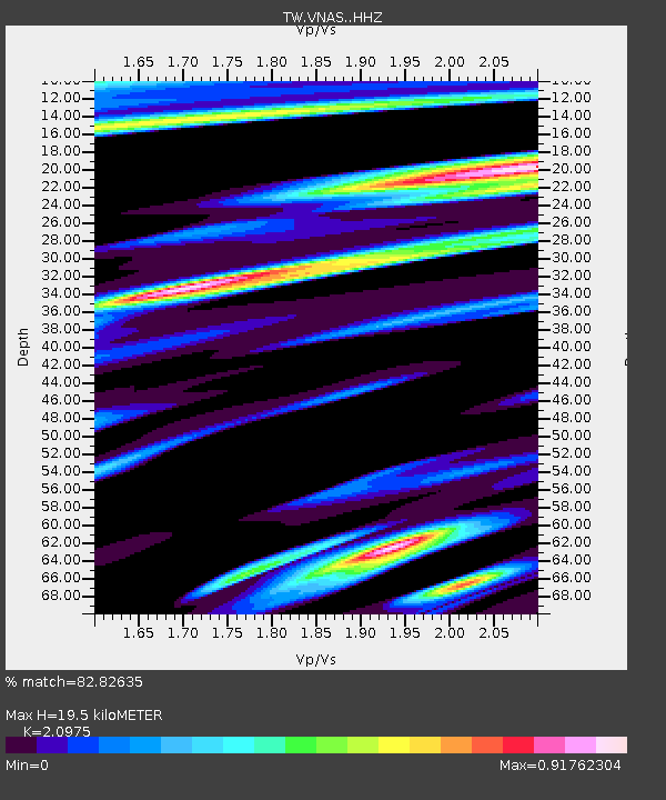
VNAS Nansha Is. - Earthquake Result Viewer
| Earthquake location: |
Solomon Islands |
| Earthquake latitude/longitude: |
-9.8/160.3 |
| Earthquake time(UTC): |
2015/05/21 (141) 19:32:57 GMT |
| Earthquake Depth: |
10 km |
| Earthquake Magnitude: |
6.0 MWB |
| Earthquake Catalog/Contributor: |
NEIC PDE/NEIC COMCAT |
|
| Network: |
TW Broadband Array in Taiwan for Seismology |
| Station: |
VNAS Nansha Is. |
| Lat/Lon: |
10.38 N/114.36 E |
| Elevation: |
2.0 m |
|
| Distance: |
49.9 deg |
| Az: |
292.416 deg |
| Baz: |
112.159 deg |
| Ray Param: |
0.068395525 |
| Estimated Moho Depth: |
19.5 km |
| Estimated Crust Vp/Vs: |
2.10 |
| Assumed Crust Vp: |
6.183 km/s |
| Estimated Crust Vs: |
2.948 km/s |
| Estimated Crust Poisson's Ratio: |
0.35 |
|
| Radial Match: |
82.82635 % |
| Radial Bump: |
400 |
| Transverse Match: |
64.42666 % |
| Transverse Bump: |
400 |
| SOD ConfigId: |
7422571 |
| Insert Time: |
2019-04-19 00:12:04.640 +0000 |
| GWidth: |
2.5 |
| Max Bumps: |
400 |
| Tol: |
0.001 |
|

Signal To Noise
| Channel | StoN | STA | LTA |
| TW:VNAS: :HHZ:20150521T19:41:21.120015Z | 5.924327 | 1.5101056E-6 | 2.548991E-7 |
| TW:VNAS: :HHN:20150521T19:41:21.120015Z | 2.570138 | 5.881286E-7 | 2.2883154E-7 |
| TW:VNAS: :HHE:20150521T19:41:21.120015Z | 2.9909246 | 5.9553105E-7 | 1.9911269E-7 |
| Arrivals |
| Ps | 3.6 SECOND |
| PpPs | 9.3 SECOND |
| PsPs/PpSs | 13 SECOND |


