You are here: Home > Network List > IU - Global Seismograph Network (GSN - IRIS/USGS) Stations List
> Station PMG Port Moresby, New Guinea > Earthquake Result Viewer
PMG Port Moresby, New Guinea - Earthquake Result Viewer

| Earthquake location: |
Qinghai, China |
| Earthquake latitude/longitude: |
35.9/90.5 |
| Earthquake time(UTC): |
2001/11/14 (318) 09:26:10 GMT |
| Earthquake Depth: |
10 km |
| Earthquake Magnitude: |
6.1 MB, 8.0 MS, 7.8 MW, 7.7 MW |
| Earthquake Catalog/Contributor: |
WHDF/NEIC |
|
| Network: |
IU Global Seismograph Network (GSN - IRIS/USGS) |
| Station: |
PMG Port Moresby, New Guinea |
| Lat/Lon: |
9.41 S/147.15 E |
| Elevation: |
67 m |
|
| Distance: |
69.8 deg |
| Az: |
118.597 deg |
| Baz: |
313.777 deg |
| Ray Param: |
0.05542167 |
| Estimated Moho Depth: |
45.75 km |
| Estimated Crust Vp/Vs: |
1.62 |
| Assumed Crust Vp: |
6.122 km/s |
| Estimated Crust Vs: |
3.767 km/s |
| Estimated Crust Poisson's Ratio: |
0.20 |
|
| Radial Match: |
97.0771 % |
| Radial Bump: |
327 |
| Transverse Match: |
94.53838 % |
| Transverse Bump: |
400 |
| SOD ConfigId: |
20082 |
| Insert Time: |
2010-03-02 15:17:53.558 +0000 |
| GWidth: |
2.5 |
| Max Bumps: |
400 |
| Tol: |
0.001 |
|
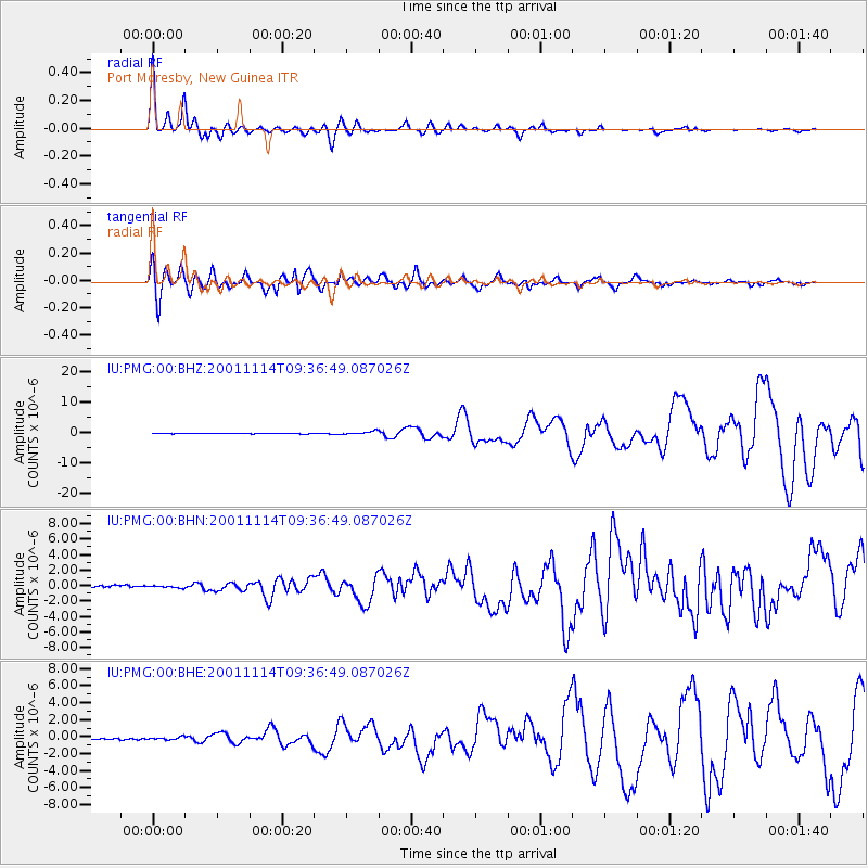
Signal To Noise
| Channel | StoN | STA | LTA |
| IU:PMG:00:BHN:20011114T09:36:49.087026Z | 1.3247195 | 1.4104891E-7 | 1.06474545E-7 |
| IU:PMG:00:BHE:20011114T09:36:49.087026Z | 1.9207602 | 1.6070744E-7 | 8.366867E-8 |
| IU:PMG:00:BHZ:20011114T09:36:49.087026Z | 5.921705 | 5.128179E-7 | 8.659971E-8 |
| Arrivals |
| Ps | 4.8 SECOND |
| PpPs | 19 SECOND |
| PsPs/PpSs | 24 SECOND |


