You are here: Home > Network List > XD14 - Illuminating the architecture of the greater Mount St. Helens magmatic systems f Stations List
> Station MG05 "Mount St Helens, WA" > Earthquake Result Viewer
MG05 "Mount St Helens, WA" - Earthquake Result Viewer
| Earthquake location: |
Solomon Islands |
| Earthquake latitude/longitude: |
-9.8/160.3 |
| Earthquake time(UTC): |
2015/05/21 (141) 19:32:57 GMT |
| Earthquake Depth: |
10 km |
| Earthquake Magnitude: |
6.0 MWB |
| Earthquake Catalog/Contributor: |
NEIC PDE/NEIC COMCAT |
|
| Network: |
XD Illuminating the architecture of the greater Mount St. Helens magmatic systems f |
| Station: |
MG05 "Mount St Helens, WA" |
| Lat/Lon: |
46.31 N/122.34 W |
| Elevation: |
1283 m |
|
| Distance: |
88.4 deg |
| Az: |
42.58 deg |
| Baz: |
254.164 deg |
| Ray Param: |
0.042631317 |
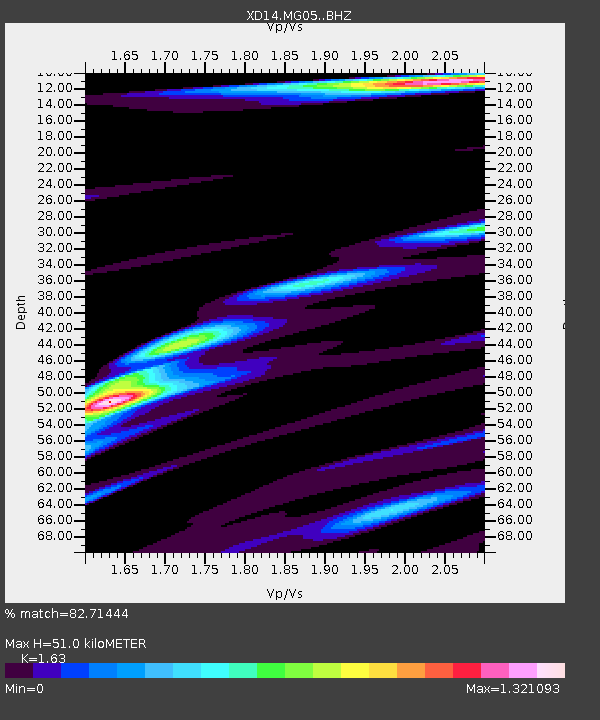
| Estimated Moho Depth: |
51.0 km |
| Estimated Crust Vp/Vs: |
1.63 |
| Assumed Crust Vp: |
6.566 km/s |
| Estimated Crust Vs: |
4.028 km/s |
| Estimated Crust Poisson's Ratio: |
0.20 |
|
| Radial Match: |
82.71444 % |
| Radial Bump: |
375 |
| Transverse Match: |
60.65331 % |
| Transverse Bump: |
400 |
| SOD ConfigId: |
7422571 |
| Insert Time: |
2019-04-19 00:12:50.507 +0000 |
| GWidth: |
2.5 |
| Max Bumps: |
400 |
| Tol: |
0.001 |
|

Signal To Noise
| Channel | StoN | STA | LTA |
| XD:MG05: :BHZ:20150521T19:45:17.659993Z | 6.078164 | 5.080045E-7 | 8.357861E-8 |
| XD:MG05: :BHN:20150521T19:45:17.659993Z | 1.3943123 | 1.0115924E-7 | 7.255135E-8 |
| XD:MG05: :BHE:20150521T19:45:17.659993Z | 2.3413262 | 2.4391105E-7 | 1.04176436E-7 |
| Arrivals |
| Ps | 5.0 SECOND |
| PpPs | 20 SECOND |
| PsPs/PpSs | 25 SECOND |


