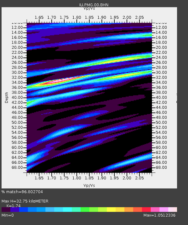
PMG Port Moresby, New Guinea - Earthquake Result Viewer

Earthquake location: Southern Sumatra, Indonesia
Earthquake latitude/longitude: -4.7/102.6
Earthquake time(UTC): 2001/02/13 (044) 19:28:30 GMT
Earthquake Depth: 36 km
Earthquake Magnitude: 6.2 MB, 7.2 MS, 7.4 MW, 7.0 ME
Earthquake Catalog/Contributor: WHDF/NEIC
Network: IU Global Seismograph Network (GSN - IRIS/USGS)
Station: PMG Port Moresby, New Guinea
Lat/Lon: 9.41 S/147.15 E
Elevation: 67 m
Distance: 44.5 deg
Az: 98.614 deg
Baz: 272.889 deg
Ray Param: 0.07181831
Estimated Moho Depth: 32.75 km
Estimated Crust Vp/Vs: 1.74
Assumed Crust Vp: 6.122 km/s
Estimated Crust Vs: 3.518 km/s
Estimated Crust Poisson's Ratio: 0.25
Radial Match: 96.802704 %
Radial Bump: 373
Transverse Match: 90.991905 %
Transverse Bump: 400
SOD ConfigId: 3744
Insert Time: 2010-03-02 15:18:08.302 +0000
GWidth: 2.5
Max Bumps: 400
Tol: 0.001

Signal To Noise

ChannelStoNSTALTA
IU:PMG:00:BHN:20010213T19:36:07.523Z2.59853364.541927E-71.7478807E-7
IU:PMG:00:BHE:20010213T19:36:07.523Z6.16309551.0533777E-61.7091698E-7
IU:PMG:00:BHZ:20010213T19:36:07.523Z7.7851772.651918E-63.4063683E-7
Arrivals
Ps4.2 SECOND
PpPs14 SECOND
PsPs/PpSs18 SECOND